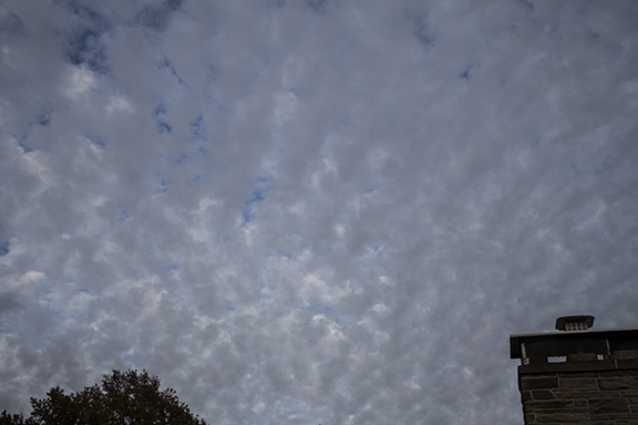
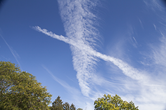
From cirrostratus to altocumulus

2017_11_26_0337_edited-Web.jpg

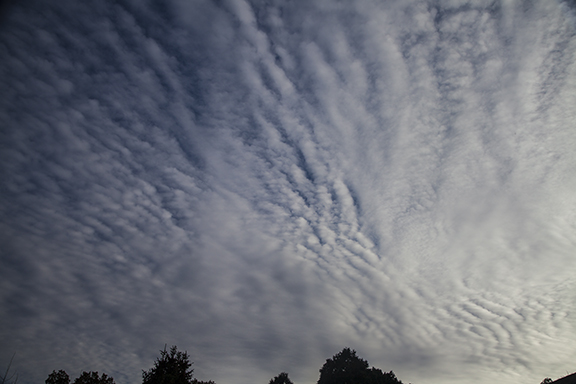
The dominant cloud type in the sky often changes in a hurry in the middle latitudes. This photo was taken less than an hour after the cirrostratus photo posted yesterday. Instead of cirrostratus the sky was now dominated by altocumulus. The altocumulus here are wave clouds, caused by ripples in the flow. Flying through these clouds would provide a bumpy ride - much like a boat ride on a lake that is covered by waves. The waves are created by the wind friction as it contacts the water surface.

Cirrostratus

2017_11_26_0330_web.jpg

This is a photo of a classic cirrostratus sky. Taken at Cedar Falls, Iowa on 11-26-2017 at 3:15 p.m. CST,  it shows diffused sunlight and the classic "milky" sky of cirrostratus. The photo also reveals several CONTRAILS (condensation trails) left by passing aircraft. The hint of a halo is visible in an arc right of the Sun. Halos are caused by sunlight being refracted as it passes through ice crystals contained in the cirrostratus. The halo was only visible in the photo - not with the naked eye. 

November Prairie Sunset

Life on the prairie includes seeing for miles and miles and miles. Sunsets can be spectacular with vivid colors and a variety of cloud shapes. The three images in this post were taken near sunset at Fort Dodge, Iowa, 11-16-2017. The sky was dominated by altocumulus clouds. These images show a few different forms of altocumulus that were in the sky at the same time. 

2017_11_16_0310_edited-web.jpg

Notice the ripples (waves) traveling in different directions at different altitudes. The waves creating these clouds are  gravity waves - waves generated at the interface between two media. Watch the wave action on a lake and you get an idea of how these waves form in the atmosphere. They occur along the interface between layers of different air density. Like a lake, which has considerably different density between the water and the air, the air motion across the lake creates waves. The same thing is happening here only the waves are occurring between layers of air. 

2017_11_16_0316-edited-web.jpg

The altocumulus are prominent in this  photo with the most distinctive wave action near the center. Temperatures were in the 40s and the sky definitely has the chilling look and feel of mid-November.

2017_11_16_0321_edited-web.jpg

The leafless trees and the setting Sun set up a picturesque November sky. Red light bathed the altocumulus cloud base with red light. The coloration brings out the three dimensional structure of the cloud formation. Notice two large birds cruising below the clouds and above the trees. The trees have lost their leaves in preparation for winter.

Asperitas - A New Cloud Type

Asperitas Cloud Photo by Craig Johnson

Asperitas Cloud Photo by Craig Johnson

Sometimes a gray day requires being a little creative with a post. Today is one of those days. So let's go back the spring of 2017 to view an unusual cloud type. Asperitas is Latin for roughness. This is one of 11 new cloud types that have been added to the newest edition of the International Cloud Atlas published by the World Meteorological Organization (WMO). The cloud type was first "discovered" at Cedar Rapids, Iowa in 2006 and features chaotic ripples and small divots. The formation did not fit into the existing cloud type system. The photo above was taken in Cedar Falls, Iowa on April 25, 2017. 

Check out the new International Cloud Atlas here: https://cloudatlas.wmo.int/search-image-gallery.html


Following a Cold Front

Yesterday's post showed a cold front from Hudson Bay into southcentral Canada and then northwestward parallel to the mountains in western Canada. Today that front has moved to eastern Hudson Bay to Lake Superior, South Dakota, then northwestward across Montana into southwest Canada. The polar front we were watching was stretched across the southern United States.

These fronts form in the middle latitudes where temperature contrasts from north to south create traveling cyclones (low pressure) and anti-cyclones (high pressure). The flow of these systems is a major part of managing the Earth's heat budget, bringing warm air north and cold air south to dissipate the middle latitude temperature differences. More about that in a different post.

For now we can say the arctic front continues to move southeastward with its air mass being modified by warmer ground, longer days, and mixing with warmer air. Ahead of the front warmer air is moving north to be cooled by colder land and water, shorter days, and mixing. 

Surface Weather Map, Wednesday, November 8, 3:00 p.m. CST. Map plotted by Digital Atmosphere  available here: http://www.weathergraphics.com/

Surface Weather Map, Wednesday, November 8, 3:00 p.m. CST. Map plotted by Digital Atmosphere  available here: http://www.weathergraphics.com/

For those of you who like to delve in to the science of all this, below you will find what is called a RAOB (RAwinsonde OBservation). It is a sounding of the atmosphere made by an unmanned balloon which radios data back to earth as the balloon ascends. This sounding is from Davenport, Iowa at 6:00 a.m. CST today. It shows a dry air mass with the red line (temperature plot) and green dashed line (dew point). The spread between the two lines is substantial, indicating dry air. The greater the difference between the temperature and the dew point temperature the lower the relative humidity. In this case the dry air is sufficient to prevent precipitation as the cold front moves southeast across eastern Iowa. There is a lot more to this chart so I am going to leave it at that for now but it is one tool used by meteorologists to gauge what is happening in the air over our heads. 

RAOB Sounding Plotted by the  RAOB Program available here: http://raob.com/

RAOB Sounding Plotted by the  RAOB Program available here: http://raob.com/

How often are balloons launched? Weather balloons are launched twice per day, 6:00 a.m. and 6:00 p.m. CST (7:00 a.m. and 7:00 p.m. EST and so on around the world). The balloons are launched simultaneously worldwide, at least twice daily, to measure upper air conditions including temperature, dew point, and wind. More than 200 other parameters are computed and plotted from these basic measurements. The chart about shows the temperature, dew point, and wind profiles (changes with height).

.Learn about weather balloons and how they are launched by clicking here. Where are the weather balloons launched i the USA? Check this website from NOAA. The launches are scheduled twice daily. Additional launches may be requested as the weather demands.

Mid-day Weather Map

SFC_1900Z_11-7-2017.gif

The map was plotted by Digital Atmosphere: http://www.weathergraphics.com/

The seasons are changing. The surface weather map at 1900Z (1:00 p.m. CST) shows the polar front stretched from California to Colorado, south to Texas, east through the Gulf States, then northeast off the cost of Canada and east of Greenland. An Arctic front is backed up against the mountains in western Canada south and east to Lake Winnipeg and northeast across northern Hudson Bay. The coldest air is behind the Arctic front where temperatures fall into the teens, single digits, to below zero. North of the polar front is a broad area of high pressure covering much of the United States. The polar high pressure connects to high pressure with arctic characteristics over the Yukon. Weak low pressure systems are moving along the polar front with  clouds and precipitation. The Arctic front is forecast to spread southeastward into the Upper Midwest, across the Great Lakes, to New England. 

Altostratus

2017_11_07_0307-web.jpg

Above: Altostratus
Below: Altostratus with a hint of the cumulus cloud type.

2017_11_07_0308-edited-web.jpg

Look closely and notice the slight hint of cumulus in the cloud photo above. The lighting reveals little lumps scattered through the cloud. Cloud names are based on a cloud shape, size, and texture. Some clouds may have several structures embedded in the main cloud type. The cloud above would likely be categorized as altostratus even though there are very small cumulus textures. The texture is easier to see in this photo than with the naked eye. Overall, it is part of a broad sheet of altostratus covering the sky. The cloud has formed in an area of cold advection (cold air replacing warmer air) over the Midwest.

Altocumulus Family: Altocumulus becomes altostratus.

Altocumulus floccus (like tufts of wool) cover the sky over Cedar Falls, Iowa during the afternoon of November 6, 2017. The cloud ceiling was measured at 11,000 ft. at the Waterloo, Iowa Airport. A combination of a moist layer and turbulence likely created the altocumulus which spread in to an altostratus layer. 

Altocumulus floccus Photo by Craig Johnson

Altocumulus floccus Photo by Craig Johnson

There were several variations of altocumulus floccus. Notice the more diffuse version below. Organized bands of waves are seen rippling through the layer creating alternating cloud bands with clear strips in between. 

Altocumulus Floccus Photo by Craig Johnson

Altocumulus Floccus Photo by Craig Johnson

Altocumulus dominate the upper right quadrant of this photo with altostratus visible across the bottom.

Altocumulus floccus Photo by Craig Johnson

Altocumulus floccus Photo by Craig Johnson

Altocumulus and altostratus mixed together as the altocumulus flattens into altostratus.

Altocumulus and Altostratus photo by Craig Johnson

Altocumulus and Altostratus photo by Craig Johnson

Clouds that look like stratus and cumulus.

Photo by Craig Johnson on I-35 north of Ames, IA, 10-30-2017

Photo by Craig Johnson on I-35 north of Ames, IA, 10-30-2017

Strong northwest winds gusting to 35 mph and a stratocumulus cloud deck made for a chilly windy day. Stratocumulus clouds have stratus and cumulus cloud characteristics, as seen here. The lumpy cloud pattern is the cumulus form while the general flat look to the clouds is the look of stratus, hence the name - stratocumulus.

All Storms Come to an End

2017_10_22_0292_edit-web.jpg

Photo by Craig Johnson

Cirrostratus and cirrus fibratus at sunset, Cedar Falls, Iowa. After several days of overcast skies and rain the end of the storm was finally visible on the western horizon. The storm's cloud shield had a sharp cutoff on its western edge. The gradual transition from a low overcast finally culminated in this dramatic sharp edge from clouds to clear sky. The cirrus edge marked a southwest to northeast jet stream that extended from the Midwest to Lake Superior and onward to Canada. The surface low by this time was northeast of the Great Lakes. Much drier air and colder air at low levels had already wiped out low and middle clouds - only the cirrus remained.

Storms begin and they have an end. This marked the end.

Mare's Tails

Photo by Craig Johnson

Photo by Craig Johnson

"Mare's tails and mackerel scales make tall ships carry low sails;" so says weather lore. In the early days of ocean going ships there were no weather forecasts. Ship's crews needed rely on their own observations and past experience to make decisions. Many times they were wrong but their forecasts were not always busts. The sky does give indications of what's coming next but given the complexity of our atmosphere sometimes similar clouds did not lead to the same result. That's because cloud altitudes and shapes are not always associated with the same weather outcome.

The scientific name for the above clouds is cirrus uncinus. Uncinus is from the Latin, meaning "curly hooks." These clouds are certainly have curly hooks! Most people know them by a different name; mare's tails. In this case the mare's tails remind us of the locks of hair on the lower hind legs of a girl horse. You can almost see the locks of hair blowing in the wind when you see cirrus uncinus. It is said that mare's tail clouds indicate approaching strong winds and suggesting ships should lower their sails because winds aloft could lower to the surface. Is it true? Not always but they are often associated with strong winds aloft that may eventually descend to the surface as a storm system gets closer.

You can try this out yourself to see if the weather lore is right. Watch the sky for mare's tails and then see observe your winds to see if they increase over time? If the winds increase how long did it take for it to become noticeable and how strong were they? Maybe the winds were already strong when you noticed the clouds. It is possible that the situation was already right for strong winds or there wasn't a storm coming after all. Or, as the weather lore states, "Mare's tails and mackerel scales make tall ships carry low sails!"

Do you want to read more about the science of high clouds? Link to a NASA web page on the subject by clicking here.


Photo by Craig Johnson

Photo by Craig Johnson

This photo was taken on December 30, 2016, just after sunrise. The sky was full of wavy clouds. There were waves superimposed on waves and the pattern was especially evident in the southeast where the Sun was rising. Elsewhere the sky was not nearly so dramatic which shows how important light is to photographers. It can make or break a picture. Without the low Sun angle these clouds would appear "ho-hum," even though they are not.

Unusual Clouds

Photo by Craig Johnson

Photo by Craig Johnson

Several types of cloud are evident in this image taken in July of 2017. First, on the right side and in the lower right corner are altostratus lenticularis cloud. The formation has lens-shaped features caused by wave action in a stable environment. The clouds appear to be very smooth but with embedded waves. The remaining clouds are higher altostratus and altocumulus or are at the cirrus level. I would say given the texture of the clouds they are in the middle cloud family - altocumulus and altostratus. 

Altocumulus

Altocumulus stratiformis, Cedar Falls, Iowa, 10-4-2017 by Craig Johnson

Altocumulus stratiformis, Cedar Falls, Iowa, 10-4-2017 by Craig Johnson

Altocumulus is a middle level cloud (6,000 - 18,000 feet) with cellular vertical development. Stratiformis is a cloud sub-characteristic indicating the cloud also has stratus (flat or layered) structure. This type is typically the thinnest of all altocumulus clouds. Notice the difference in thickness of the cloud layer. Some of the cells, particularly in the lower right quadrant are thicker, showing a more vertical structure. Clouds on the left side of the photo are thinner with a more stratus structure. This cloud type is formed by water vapor that condenses into water droplets.

Peering into a Thunderstorm

Photo by Craig Johnson, 7-6-2014

Photo by Craig Johnson, 7-6-2014

Taking close-ups of clouds can produce spectacular results. This photo of a thunderstorms - close-up - reveals the majestic turbulence found in a thunderstorms. The coloration is due to the filtered light that is common at sunset. In this case, an orange sunset was casting an orange pall over the cloud that was contrasted by low level fractostratus across the top of the image.