
Banner video: Cumulus form and dissipate on an early October afternoon over Cedar Falls, Iowa.
Clouds in Motion - The Story of the Sky
Clouds are like wind vanes - they show us which way the wind is blowing. Still photos are a snapshot in time. When we look at the sky we see the clouds in motion. When we speed up that motion with time lapse photography hidden secrets are revealed. We see condensation and evaporation. We see wind shear - changes in wind speed and direction. Clouds in Motion brings the sky to life.
In the videos below, we see clouds form, grow, move, and disappear. Look first for the over all direction and speed of motion. When cloud direction and speed change caused by wind shear.
There are two types of wind shear; directional and speed. Speed shear is visible when cloud layers move at different speeds. Directional shear is more obvious. That is directional shear. I hope enjoy Clouds in Motion.
Wind Shear
The following video from NASA shows how winds change with height.
Altocumulus
Click image or button to play videos.

Looking down at altocumulus from 25,000 feet (23sec)

Time Lapse of altocumulus (36 sec)
A gravity wave in the atmosphere is up and down air motion. Gravity waves are caused by air encountering an obstacle, such as a mountain or the updraft of a thunderstorm, or even another gravity wave. The waves are like the waves that form when a rock is thrown into water. In the air they travel away from the obstacle, sometimes for hundreds of miles, forming many of the simple and complex wavy patterns that appear in clouds. Larger gravity waves can cause changes in air pressure and trigger thunderstorms.
Cirrus

Cirrus, Altostratus, Altocumulus in motion

Cirrus and contrail
Cumulus
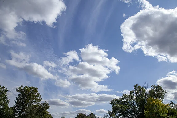
Cumulus humilus are humble cumulus clouds. Small cumulus form on days when there is shallow weak instability. Weak updrafts develop due to solar heating. The earth heats the lowest layer of air near the ground, forming the cumulus, then dissipate when heating decreases during the late afternoon and evening. As the air cools the updrafts cease and the clouds evaporate.
In this video cumulus form and evaporate during the afternoon as they move from west to east. Above the cumulus are streaks of cirrus. Near the end of the video a layer of altocumulus appears in the upper right of the video. This video was made on October 2, 2020 at Cedar Falls, Iowa.
The above was shot on October 12, 2020 in Cedar Falls, Iowa. It shows small cumulus clouds (cumulus humilus) forming in a cool air mass behind a cold front. Sunshine is warming the surface, creating weak updrafts. The updrafts are raising moisture left over from light showers (.02”) that fell shortly after sunrise. Condensation in the rising air is forming clouds which evaporate quickly in the surrounding dry air mass. The time lapse covers about an hour from around 11:10 a.m. to 12:10 p.m. CDT.
Stronger winds aloft are shearing off the tops of the cumulus clouds. The shearing is stirring the air and mixing in drier surrounding air. Think of the process as follows. Light showers wet the ground. Gusty winds and the rising Sun evaporate the rain and allowing it to rise where it condenses into a cloud at a higher level. The mixing of the drier air evaporates the cloud several thousand feet above the ground. The process will start all over again maybe hundreds of miles away.
Stratocumulus
Multiple Cloud Types
Videos are added regularly!