
The Weather Blog
To purchase our 24” x 36” full color cloud chart, go to our online store. It is suitable for framing in a standard 24” x 36” frame.

Learn how to identify clouds by following the Clouds of the Day posts below.


Clouds of the Day - February 4 - 5, 2021
/
February 5, 2021

February 4, 2021

February 4, 2021

FEbruary 4, 2021
February 4, 2021
Clouds of the Day - January 23, 2021
/
Cirrostratus with a dim halo.

Cirrostratus with a colorful halo.

Birds attacking a bird feeder.

Cirrostratus

Cirrostratus with diffuse sunlight shining through the clouds.

another view of cirrostratus and a dim halo.


Clouds of the Day - Tuesday, January 12, 2021
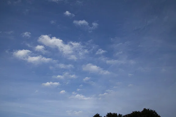
/The photos below were taken at 7:45 this morning looking southeast from Cedar Falls, Iowa. Bands of primarily cirrostratus were stretched west to east across the southeastern sky. There were also altostratus along the north edge of the cirrus band. The altostratus have small cumulus features embedded. HIgher in the sky were altocumulus.
It would be possible to classify all of the clouds as Altostratus and Altocumulus types because of their dense features but as the sun moved higher these clouds looked to be much thinner than they appear here. This is a good example of how cloud types can sometimes be hard to determine. It comes down to how high they are which is difficult to determine.

Cirrostratus with Altostratus along the top of photo

Cirrostratus with Altocumulus top right
Clouds of the Day - Tuesday, January 5, 2021
/Finally, a break in the clouds and Sunshine!

Cirrostratus clouds with a CONTRAIL (condensation trail)

Cirrostratus with a CONTRAIL.
Clouds of the Day - Monday, January 4, 2021
/
Hoar Frost with stratus cloud in the background.

More hoar frost. See the post below for more about hoar frost.
Clouds of the Day - Sunday, January 3, 2021
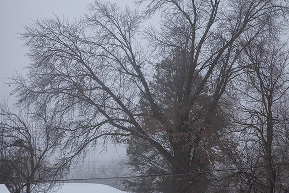
/Hoar frost coated trees, power lines, and fences with a fuzzy layer of white. Hoar frost consists of hair-like ice crystals that form in freezing fog and light winds. The crystals form on objects that are below freezing as water vapor condenses directly into ice crystals. Tree branches make an excellent base for the crystals to form and increase in thickness. Temperatures were in the teens when the freezing fog deposited the crystals.

THese trees were back-lit by the morning sun in the southeastern sky. Fog had lifted and is visible as a layer of stratus cloud in the background. Below are photos of hoar frost that formed on trees.

Hoar Frost

Picuresque Hoar Frost. Stratus is seen in the background.

Hoar Frost with stratus formed from fog.

Hoar frost on a wire
Clouds of the Day - Saturday, January 2, 2021
/A foggy day with visibilities less than 1/2 mile.
Fog. Notice the diminished visibility in the distance along the lower left part of the photo.
Clouds of the Day - Friday, December 25, 2020
/This morning dawned with clear skies but a band of stratocumulus clouds crossed the area late morning into the early afternoon. The clouds formed in a region of warm advection (relatively warmer air aloft moving over a layer of cold air in contact with the surface. Stratocumulus form in a layer of stable air that includes weak upward motion caused by warmer air aloft being lifted weakly slides upward over a lower layer of cold air. Our low this morning was -1 degree F.

Stratocumulus

Stratocumulus
Clouds of the Day - Monday, December 21, 2020
/As you can see the day began with a clear sky. The first photo on the left was taken before the Sun climbed above the southeastern horizon. The bright light across the bottom of the photo is sunlight being scattered by the rising sun. Across the top of the photo is darker sky. The atmosphere higher in the sky is still dark because the sunlight has not reached it yet. As the sun rises higher the entire sky will brighten.
The stratocumulus clouds below are caused by cold advection. As temperatures warmed in the morning the air became weakly unstable in the lower levels. Because there was sufficient moisture available, the rising air cooled to its dew point and condensed in to stratocumulus clouds. Stratocumulus are not very deep because the atmosphere above the cloud tops includes sinking motion which warms the air creating a stable layer of air above the rising clouds below. This stops the rising motion and keeps the clouds in the low levels of the atmosphere.

Sunrise

Stratocumulus

Stratocumulus

Stratocumulus
Clouds of the Day - Thursday, December 17, 2020
/While many clouds are exciting to look at, stratus clouds are not exciting. Stratus are uninteresting featuring diffuse cloud bases that are uniform in shape and coloration. They are flat, indistinct, with not cloud definition. At most it is possible to get a little drizzle out of stratus but that is fairly rare. Here is a photo of stratus - indeed a very uninteresting cloud.

Stratus
Anatomy of a Winter Storm - The Cold Front - Wednesday, December 23, 2020
/The meteographs below show how temperature, dew point, relative humidity, pressure, and wind changed as a strong cold front swept across northeast Iowa today. This is a great example of the relationships between different weather elements. For those of you in education, who teach a weather class to upper elementary through high school students, the charts below illustrate how the elements changed in relation to each other with the passage of a strong cold front.
The first chart shows how temperature (solid red line), relative humidity (dashed blue line), and dew point (dotted green line) reacted as the front passed. Notice the sharp drop in temperature just before 12:00 p.m. The drop is shown by the straight down drop-off in the line. The drop continued through 8:50 p.m. which is the time the chart was captured. Colder air was behind the front. The cold front reached the weather stations at 11:15 a.m.
The dew point also trended steadily down after the passage of the front and the dew point was unsteady as the colder air followed the front. Normally the relative humidity would increase as the temperature cooled but in this case the dew point was also dropping so instead of rising the dew point was essentially steady. Colder air was attempting to increase the relative humidity while the the lowering dew point indicated drier air which would lower the relative humidity. The relatively remained relatively unchanged as the effects counterbalanced each other.
The second meteograph traces the barometric pressure. Notice the change from falling to rising at the same time as the temperature began to turn colder. The pressure rise indicates the passage of the front with it’s colder heavier air mass behind.
The last chart below is the wind speed in miles per hour. Notice the period of zero wind speed in the morning. The anemometer failed during that period so there was a zero reading. Just after noon the anemometer corrected itself. From that point on it recorded the wind speed (solid line) and wind gusts (red stars). The wind changed from southerly to westerly after the front passed (not shown here). Wind speeds recorded by this anemometer are always less than in the open country because of numerous trees around our location. We still recorded wind gusts between 20 and 30 mph. Actual speeds in the open country were greater than 40 mph. Winds were also gusty before the anemometer failed as you can see on the chart.

Below is the surface map at 12:00 p.m. (Noon) CST. This is 45 minutes after the cold air reached Cedar Falls, Iowa. The leading edge of the cold air is marked by pressure tendency rises along a line dropping south out of the low center into eastern Iowa and northeastern Missouri. Look for the “check marks” on the right side of some of the station model plots in eastern Iowa and eastern Missouri. The fronts on the map below are plotted by NCEP which does not analyze the boundary on the map. The station model plots and the isobars are plotted by the Digital Atmosphere program available at www.weathergraphics.com. You can easily see the temperature drop along and behind the pressure rises.

Major Snowstorm for the Northeastern United States - 12-16-2020
/This morning’s surface map shows low pressure organizing over the southeastern United States with a low center along the Kentucky-Tennessee border and another center on the South Carolina coast. These lows will merge into one large storm that will dump heavy snow and rain as it moves to the northeast along the East Coast.

The map below shows the northeastern United States. Cold high pressure centered over southeastern Canada. Using the plotted data note the temperatures. If you need help reading the surface model plots, go to our homepage and scroll down to the section about decoding maps. Click on the image to learn the station model plot format. Temperatures range between -15 to - 28 degrees F under the high pressure center.
Meanwhile low pressure is organizing just off the southern edge of this map. Notice how the temperatures and dew points are higher across the southern portion of the map. Readings are below freezing north of the Ohio River and north of Virginia and Maryland. Light snow is indicated at stations in Ohio, Indiana, and Illinois.
There will be more maps and information to follow. For forecasts be sure to follow your local forecasts at www.weather.gov (National Weather Service). That website has links to all forms of weather information about the storm. This website includes links to a massive amount of data and images.

Maps plotted by Digital Atmosphere which is available at www.weathergraphics.com.
Clouds of the Day - Wednesday December 16, 2020
/Vapor rises from the chimney of a neighbor’s house (lower left) as the Sun skims the horizon in the lower right. This was just after sunrise. The view is looking to the southeast and the temperature was 15 degrees F. Snow is visible on the roof of the house. There is 2 inches of snow on the ground. The morning low of 14 degrees occurred at 7:40 a.m., 30 minutes before this photo was taken.

December Sunrise - Altocumulus - Cedar Falls, Iowa

Cumulus

Cumulus

Stratocumulus

Cumulus
Clouds of the Day - Tuesday, December 15, 2020
/
Altostratus and Cirrostratus - Photo by Craig Johnson, Cedar Falls, Iowa
Clouds of the Day - Monday, December 14, 2020
/
Cirrus

Cirrus

Cirrostratus
Clouds of the Day - Saturday, December 12, 2020
/
Altocumulus

Stratocumulus

Stratus and a Bald Eagle - Along Cedar River at Cedar Falls, Iowa (Bald Eagle visible sitting on a limb near the Center of the photo)

Reflections in the Cedar River with Stratus Overhead