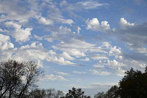
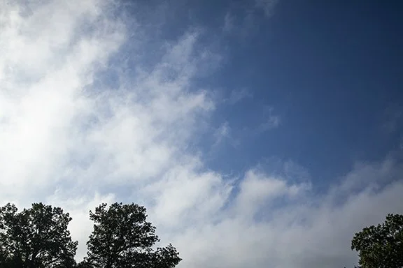
Clouds of the Day, Wednesday, November 2, 2022- Cirrus fibratus and CONTRAILS
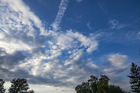
After days of clear skies we finally had clouds from the Cirrus family move overhead from the west. CONTRAILS get their name from Condensation Trails - man-made clouds that form from the condensation of water vapor in jet engine exhaust. As long as there is sufficient moisture aloft naturally the addition of more moisture from the engine exhaust raises the relative humidity high enough to condense into a CONTRAIL. Several CONTRAILS are visible in the photo below and over time they either spread into a pattern seen here from the bottom left to the upper right of the photo or they may evaporate where the air is drier as is seen in the CONTRAIL visible in the center of the photo and near the bottom of the screen.

NOTE: Do you see the Moon in the lower left?

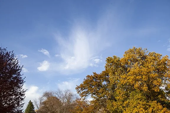
Photos by Craig Johnson, Weather Briefing, LC

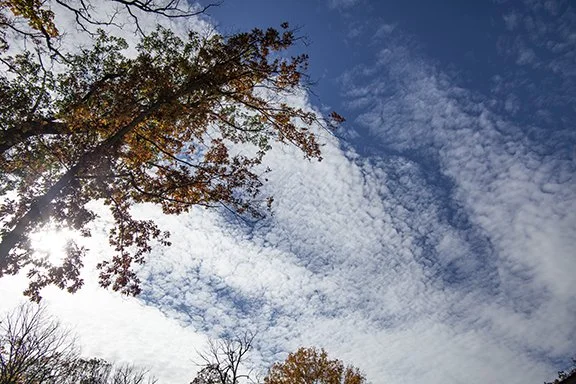
Photos are by Craig Johnson, Weather Briefing, LC

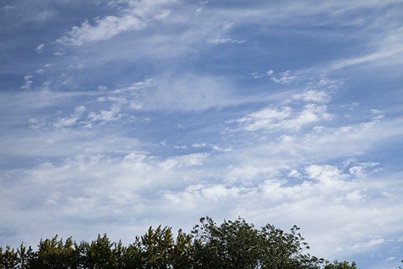
The photo above is an excellent example of Cirrus fibratus. This is looking northwest in the direction of where the Cirrus were coming. There are also wave clouds in the lower center of the photo which are cirrostratus or high altostratus. Our high temperature reached 76 degrees - a beautiful November day.

It's Snowing on High

These photos were taken on a recent fine fall day with mild temperatures and light winds. It is deceiving. Overhead above 16,000 feet it is much colder and windier. In fact, at any time of the year it is much colder overhead with temperatures often well below zero. This time of year, it is getting colder here on the ground, and aloft. The transition to winter is underway. These clouds are cirrus with their soft hairlike filaments and protuberances. They are also made of mainly ice crystals. Fallstreaks, also called virga, are trailing the upper clouds as they fall through layers with different wind speeds. It is a “snowstorm” aloft that will someday reach the ground as lower layers cool below freezing.

Jets and Cirrus

Our sky can put on quite a show. These show CONTRAILS (Condensation Trails) and clouds. In fact, a CONTRAIL is nothing more than a manmade cloud that formed with the assistance of nature. Jets exhaust a trail of water vapor that condenses in the cold air aloft. If the air is too dry the vapor does not become visible in the form of a cloud. If there is enough moisture in the air (even though the sky may be clear) it will condense forming CONTRAILS. Here we see a mixture of cirrus clouds and CONTRAILS. They change shape with time as they move through different weather regimes overhead such as changes in temperature and wind direction and speed.

CONTRAILs with cirrus fibratus, cirrocumulus, and fallstreaks

Contrails with cirrus fibratus

Cirrus

One Day, Three Cloud Types

The top photo in today’s post show Cirrus fibratus clouds. The clouds are made of ice crystals that form a pattern of thin filaments. A puffy Cumulus humilus cloud is in the lower left corner with a fractured cumulus humilus in the upper left.

In the second photo we see Cirrostratus and Cirrus fibratus in bands. The Cirrostratus have formed a continuous cloud sheet while the Cirrus fibratus are the filaments with blue sky visible through them. There is a faint hint of a halo to the left of the Sun in a vertical arc. In the lower center are very small Cumulus humilus.

The second photo is a sky filled with Stratocumulus in a cloud deck with both Cumulus and Stratus characteristics. It was a cold windy day and the cloud deck formed in the cold air mass during the afternoon, covering the Cirrus above.

Altocumulus

Fine fall days include sunshine, light winds, and beautiful cloud patterns stretched across the sky. These altocumulus clouds spread quickly overhead as strong mid-level winds ushered in weakly unstable air. Notice the cellular look to the clouds shaped as ovals surrounded by narrow bands of blue sky. The patterns change from one side of the photo to the other showing slightly different levels of instability.

The clouds in the lower left corner have more stratus characteristics than cumulus while the clouds at the far right are definitely in the cumulus family with greater vertical dimension to the clouds. Be sure to look up this time of year because we are transitioning to winter with more energetic storms and many interesting cloud types to see.

Photo copyright, Craig Johnson

Artistic Cirrus Clouds

Photo taken 10-15-2022 in Cedar Falls, Iowa. Copyright Craig Johnson, Weather Briefing, LC

Cirrus has a flair for the artistic and the dramatic! The clouds look out of focus but they aren’t. The soft edges are caused by ice crystals blowing off the cloud edges by winds in excess of 100 mph at cloud level. Cirrus are noted from hair-like filaments which are plainly visible in this photo.

Wind speeds reach speeds in excess of 100 mph along the jet stream, especially from fall through spring. Jet stream winds are strongest during the cold season when the temperature contrast between the poles and the lower mid-latitudes is greatest. Speeds are slower during the summer.

Below is the upper air flow this morning at approximately 30,000 ft. The direction is from the north and you can see the counterclockwise circulation, the telltale sign of a low pressure center near lower Michigan. The map covers the far western Great Lakes to the Northern and Central Plains. The wind plots use the same convention used to plot surface maps. Winds over Iowa are in excess of 110 knots or 127 mph from the north central to the southeast. Cirrus are found above 16,000 feet and can be seen higher than 30,000 feet. The cirrus in this photo are at or above the level of the jet contrail.

Clouds of the Day: Cloud Invasion

Our day began with patchy mid-level clouds but as low level moisture increased a Stratocumulus deck formed as shown in the sequence of photos below. Showers and thunderstorms are expected along a cold front tonight and tomorrow. Strong winds and hail will be possible.

Altocumulus and Altostratus at 11:00 AM this morning. Match the time on the weather maps below.

Also at 11:00 AM high Altocumulus and Altostratus appear above the small cumulus cloud.

By mid-afternoon a stratocumulus cloud deck had overspread the area. Dew points quickly increased from the mid-40s into the 50s due to southerly surface winds from the Gulf of Mexico.

Another look at the Stratocumulus deck. The sky appeared to be clear above the clouds although there may have been mid-level clouds in patches similar to what we had in the morning.

The dotted green line is the dew point for the 48 hours ending 3:45 PM, Tuesday, Otober 11, 2022. As mentioned in the text above with the photos moisture was increasing during the day which formed Stratocumulus clouds by mid-afternoon. Low level upward motion caused the moisture to rise and the cooling caused condensation and cloud formation. The increasing dew point can be seen beginning after 4:00 AM on October 11th (today). You can see that the dew point stopped increasing shortly before Noon and as clouds covered the sky, the temperature (red line) cooled and the relative humidity increased. If the dew point stays the same and the temperature cools the relative humidity increases.

Colder air headed to the Northern Plains

Refer to the Station Model Plot Tutorial to read the weather station observation plots. Temperatures in the 40s to lower 50s are being reported from a Canadian air mass entering the northern and central plains. The leading edge of the cold air extends across the Dakotas to Wyoming and western Montana. The weather is quiet ahead of this system with temperatures in the 60s and 70s. High pressure covers the eastern United States and much of the western United States. See the the Weather Briefing links on our home page for the latest discussions from the National Weather Service. Follow the front in future posts here.

USA Surface Map with Station Model Plots - 11:00 AM, tUESDAY, October 11, 2022, Plotted by Digital Atmosphere; Software available from www.weathergraphics.com.

wEATHER dEPICTION mAP - 11:00 AM, tUESDAY, oCTOBER 11, 2022, pLOTTED BY dIGITAL aTMOSPHERE sOFTWARE, WWW.WEATHERGRAPHICS.COM; tHIS MAP PLOTS: WEATHER, VISIBILITY, CLOUD COVER, CLOUD CEILING (BASE), WHETHER OBSERVATION IS AUGMENTED BY AN OBSERVER (CIRCLE) OR ENTIRELY AUTOMATED (SQUARE); WIND DIRECTION AND WIND SPEED.

sURFACE WIND DIRECTION mAP - tHIS MAP DRAWS STREAMLINES WHICH SHOW THE FLOW OF AIR AT THE SURFACE FOR 11:00 AM, tUESDAY, oCTOBER 11, 2022. nOTICE HOW THE AIR IS FLOWING CLOCKWISE OUT OF HIGH PRESSURE CENTERED OVER Virginia. tHE AIR IS CONVERGING AT THE COLD FRONT CROSSING THE UPPER MIDWEST AND THE gREAT pLAINS.

Altocumulus under a CONTRAIL and Cirrus

The Altocumulus in this photo are the puffy dense clouds from the left side to lower right. These are mostly Altocumulus because they are clouds with vertical development in the mid-levels but there are Altostratus visible in the lower right. Very high Altocumulus is found in the upper right along with a few Cirrus. The cloud elements are very small which means they are very high. Remains of a CONTRAIL (Condensation Trail) are visible in the upper center. It is water vapor condensing into water droplets or ice crystals from a passing jet aircraft.

Ideal Fall Weather - Crisp Nights and Sunny Days

The following photos taken on October 8, 2022 show the opening act of the fall colors show for 2022. The top photo shows very thin Cirrostratus clouds. They also have the look of very high altostratus. This is one of those times when the cloud type can go either way.

This photo from the same day shows the spreading out of CONTRAILS (Condensation Trails) These clouds are at the Cirrus level with the aircraft flying between 30,000 and 40,000 feet overhead. The CONTRAILS are spreading into thin Cirrostratus with the clouds near the bottom of the screen creating fall streaks of ice crystals precipitation in the cold atmosphere.

Clouds of the Day: Changing by the Hour

Cooler air has spread across the area today with northerly breezes and the sky filled with a variety of Cirrus clouds and Altocumulus and Altostratus. Every hour brings a new set of clouds moving to the southeast.

Cirrus spissatus, Cirrostratus, Altocumulus, Cumulus, Cumulus fractus; Copyright 2022, Craig Johnson, Weather Briefing, LC

Close up of Altocumulus (center) with Cumulus in the foreground; Copyright 2022, Craig Johnson, Weather Briefing, LC

Cirrus fibratus overhead; Copyright 2022, Craig Johnson, Weather Briefing, LC

Cirrus spissatus, Cirrus fibratus, Cumulus; Copyright 2022, Craig Johnson, Weather Briefing, LC

Cirrus fibratus, Cirrus spissatus, Cumulus; Copyright 2022, Craig Johnson, Weather Briefing, LC

Cirrus fibratus, Cirrus spissatus, Cirrostratus; Copyright 2022, Craig Johnson, Weather Briefing, LC

Cirrus spissatus, Cirrus fibratus, Cumulus; Copyright 2022, Craig Johnson, Weather Briefing, LC

Large sheet of Cirrostratus, Cirrus floccus with virga (fall streaks).

Close-up of cirrus virga (fall streaks) and altocumulus

Altocumulus (Lower Left) and cirrocumulus (Upper Right).

Altocumulus with commercial Jet emerging from above the clouds.

This chaotic looking skies has A LOT going on. There are several waves of Cirrus in the background right of center. There is Cirrus fibratus on the left side, Altocumulus and altostratus left and right (cellular clouds).

Close-up of the Altocumulus (Left) and Cirrus streamers with cumulus in the foreground (right).

A broad sheet of Altocumulus, looking west

Closer view of Altocumulus, looking southwest and west.

Clouds of the Day: Tufts of Wool, Curls, Fibers, Waves, and a Bonus!

Another upper level disturbance is moving east southeast across the Upper Midwest this morning as a surface cold front with cooler air and much lower dew points exits southeast Iowa this morning. Behind the front temperatures in Iowa fall into the 60s with dew points dropping into the 40s now entering northern Iowa with 70s and 50s for temperatures in the south. It is a breath of fresh air outside this morning. As of this posting our weather station reports a temperature of 70 F with a dew point of 54 F.

We have a series of interesting cloud photos this morning. I will be adding more comments as the day goes on when I have more time. In the meantime enjoy the photos including two bonus photos. You will be able to pick them out.

Altocumulus floccus. Photo copyright 2022 by Craig Johnson, Weather Briefing, LC. Cedar Falls, Iowa.

Altocumulus floccus. Photo copyright 2022 by Craig Johnson, Weather Briefing, LC. Cedar Falls, Iowa.

Cirrus fibratus, Cirrostratus, and Altostratus. Photo copyright by Craig Johnson, Weather Briefing, LC. Cedar Falls, Iowa. Photo copyright 2022 by Craig Johnson, Weather Briefing, LC. Cedar Falls, Iowa.

Cirrus fibratus and Cirrostratus. Photo copyright by Craig Johnson, Weather Briefing, LC. Cedar Falls, Iowa. Photo copyright 2022 by Craig Johnson, Weather Briefing, LC. Cedar Falls, Iowa.

The Bonus: Cirrus fibratus, Cirrus uncinus, undulations (waves), Altocumulus, and left parhelia (optical effect left of the Sun). Photo copyright 2022 by Craig Johnson, Weather Briefing, LC. Cedar Falls, Iowa.

The Bonus: Close up of Cirrus fibratus with left parhelia. Photo copyright 2022 by Craig Johnson, Weather Briefing, LC. Cedar Falls, Iowa.

Cirrus uncinus, Cirrus fibratus, Cirrocumulus, Altocumulus. Photo copyright 2022 by Craig Johnson, Weather Briefing, LC. Cedar Falls, Iowa.

Cirrus fibratus, Cirro stratus, Altocumulus, Altostratus. Photo copyright 2022 by Craig Johnson, Weather Briefing, LC. Cedar Falls, Iowa.

Cirrus fibratus with undulations (waves). Photo copyright 2022 by Craig Johnson, Weather Briefing, LC. Cedar Falls, Iowa.

Cirrus fibratus, Cirrostratus, fractured Altostratus. Photo copyright 2022 by Craig Johnson, Weather Briefing, LC. Cedar Falls, Iowa.

Cirrus fibratus, Cirrus spissatus with fall streaks, fragments of Altostratus. Photo copyright 2022 by Craig Johnson, Weather Briefing, LC. Cedar Falls, Iowa.

Clouds of the Day: Tufts of Wool and Castles in the Sky

Altocumulus floccus at dawn (like tufts of wool). Photo copyright 2022 by Craig Johnson, Weather Briefing, LC. Cedar Falls, Iowa.

Altocumulus floccus (like tufts of wool). Photo copyright 2022 by Craig Johnson, Weather Briefing, LC. Cedar Falls, Iowa.

Altocumulus castellanus (castles in the sky). Photo copyright 2022 by Craig Johnson, Weather Briefing, LC. Cedar Falls, Iowa.

Altocumulus castellanus (castles in the sky). Photo copyright 2022 by Craig Johnson, Weather Briefing, LC. Cedar Falls, Iowa.

Clouds of the Day: Variety is the Spice of Life

On some days the sky puts on a show. The photos below chronicle the sky of today from 9:00 AM CDT to 7:15 PM. The day began with fog but by 9:00 AM the fog was evaporating, leaving a clear sky for most of the day. Then during the late afternoon an upper air disturbance triggered cumulus clouds and eventually one flash of lightning and a few sprinkles at 7:00 PM. Along the way a new unusual cloud type passed over our heads. Two photos of the new cloud type are included along with an explanation. Daylight ended with sunset and vivid red light bathing the western sky. Whew! Our weather was busy today. All photos taken by Craig Johnson, Weather Briefing LC, from our yard.

Fog evaporating into thin air. The day began with rather mundane weather - nothing special here. Photo copyright 2022 by Craig Johnson, Weather Briefing, LC. Cedar Falls, Iowa.

More remnants of morning fog just before the sky cleared. Photo copyright 2022 by Craig Johnson, Weather Briefing, LC. Cedar Falls, Iowa.

But then the action began. Late afternoon cumulus building nearly overhead. Photo copyright 2022 by Craig Johnson, Weather Briefing, LC. Cedar Falls, Iowa.

Things began to get more interesting. Altocumulus cloud bases with a larger altocumulus building skyward visible above the cloud base. Photo copyright 2022 by Craig Johnson, Weather Briefing, LC. Cedar Falls, Iowa.

And then we were treated with one of the newest cloud types: Altocumulus asperatus cloud. Photo copyright 2022 by Craig Johnson, Weather Briefing, LC. Cedar Falls, Iowa.

As described by the Cloud Appreciation Society, which first proposed the cloud name, The cloud looks like the choppy surface of the ocean on a windy day. The name comes from the Latin word ‘aspero,’ which means to make rough. The word was used by Roman poets to describe the rough sea associated with a cold north wind.

Asperatus is a supplementary feature of Altocumulus and stratocumulus clouds. Altocumulus are mid-level cumulus clouds and stratocumulus are low level clouds. As a supplement the cloud would be either an altocumulus asperatus or a stratocumulus asperatus.

On June 20, 2006, Jane Wiggins took a picture of asperitas clouds from the window of a downtown office building in Cedar Rapids, Iowa, She sent the photo to the Cloud Appreciation Society where in 2009 Gavin Pretor-Pinney, founder of the Cloud Appreciation Society, began working with the Royal Meteorological Society to promote it as an entirely new cloud type. Added to the International Cloud Atlas as a supplementary feature in March 2017, it is the first cloud formation added since cirrus intortus in 1951.

Information for this description comes from the Cloud Appreciation Society webpage and also Wikipedia.

Wikipedia
Cloud Appreciation Society

Altocumulus asperatus. Photo copyright 2022 by Craig Johnson, Weather Briefing, LC. Cedar Falls, Iowa.

Cumulus congestus partially hidden just right of center above the lower cloud bases. Photo copyright 2022 by Craig Johnson, Weather Briefing, LC. Cedar Falls, Iowa.

Crepuscular rays with altostratus and the dark bases of cumulus clouds. Photo copyright 2022 by Craig Johnson, Weather Briefing, LC. Cedar Falls, Iowa.

Cumulus congestus rising above lower cumulus clouds. Photo copyright 2022 by Craig Johnson, Weather Briefing, LC. Cedar Falls, Iowa.

A chaotic sky with several types of mid-level clouds related to cumulus, altocumulus, and the asperatus clouds. Photo copyright 2022 by Craig Johnson, Weather Briefing, LC. Cedar Falls, Iowa.

A faint reddish glow illuminates low cumulus clouds while delicate mid-level altocumulus lacunosus clouds are visible against the blue sky. Photo copyright 2022 by Craig Johnson, Weather Briefing, LC. Cedar Falls, Iowa.

FINALLY, a dramatic Reddish glow near sunset. Photo copyright 2022 by Craig Johnson, Weather Briefing, LC. Cedar Falls, Iowa.

Photo copyright 2022 by Craig Johnson, Weather Briefing, LC. Cedar Falls, Iowa.

It all comes to an end. cumulus congestus with virga (raindrops evaporating before they reach the ground) in the foreground and higher white altostratus and altocumulus with virga (also called fall streaks) in the distant background. Photo copyright 2022 by Craig Johnson, Weather Briefing, LC. Cedar Falls, Iowa.

All of these photos were taken today between 9:00 AM and 7:15 PM at Cedar Falls, Iowa.

Sky Color Changes at Sunset

It is common to see color changes to the sky around sunrise and sunset. Instead of blue sky the sky glows yellow or red bathed in light from the Sun.

The Sun was low on the western horizon when this photo was taken on the evening of September 17, 2022. The camera was looking to the south, so the SUN WAS to the right of this photo. Contrast this photo with the one below. Photo copyright 2022 by Craig Johnson, Weather Briefing, LC. Cedar Falls, Iowa.

This photo is looking slightly north of west. It was taken abour 1 mINUTE LATER. The Sun is LOCATED BEHIND THE TREES AT THE LOWER LEFT OF THE PHOTO. iNSTEAD OF THE BRIGHT YELLOW GLOW IN THE FIRST PHOTO THE COLOR HERE IS VERY PALE AND WASHED OUT.. Photo copyright 2022 by Craig Johnson, Weather Briefing, LC. Cedar Falls, Iowa.

First Signs of a Storm System

Smoke from western wildfires creates a hazy sky. Photo copyright 2022 by Craig Johnson, Weather Briefing, LC. Cedar Falls, Iowa.

The same photo with the haze artificially removed. Photo copyright 2022 by Craig Johnson, Weather Briefing, LC. Cedar Falls, Iowa.

This is a Larger version of the photo on the right above. The smaller cellular clouds could be Cirrocumulus rather than altocumulus. It is splitting hairs. Estimating cloud heights takes experience and even then it can be tough especially when looking at a photo like this. It is much easier to determine the difference between low and middle level clouds. The difference between cloud types is not an exact science and remember, clouds can be mixtures of different types and don’t always follow nice neat rules. The size of the cloud elements helps when estimating how far away they are. Smaller clouds are often just farther away. Photo copyright 2022 by Craig Johnson, Weather Briefing, LC. Cedar Falls, Iowa.

Yesterday we had patch cirrus that was visible through a smoke filled sky courtesy of the western U.S. wildfires. Today more clouds are returning to Iowa’s skies. While the clouds are more numerous and more interesting than yesterday, they still have very high bases due to the stability of the air and no upward forcing that would create lower clouds.

A storm system approaching from the west will be increasing the relative humidity and dew points due to increasing southerly winds during the next 48-hours. As water vapor is added to the air and temperatures warm, lower-level air will become a little less stable which will eventually lead to showers and thunderstorms. Upward motion, from the flow of air through the storm system and increasing low-level instability underneath the upper flow will generate showers and thunderstorms.

Clouds today are the vanguard of the next storm, with high altocumulus indicating some instability in the upper levels of the atmosphere. The storm will clear the upper air of any smoke from the western wildfires.

The two small photos above are the same photo. The one on the left shows the sky as it really looks. We continue to have high based haze from the western wildfires. The right photo has had the haze artificially removed by digital photo software. The larger third photo makes it easier to see the cirrus, altocumulus, and altostratus clouds. The cirrus are very high and wispy with ragged edges. It takes an eagle eye to spot them. The smooth based opaque clouds are very high altostratus and the lumpy clouds are altocumulus - also very high. This photo is looking south southeast.

Photo copyright 2022 by Craig Johnson, Weather Briefing, LC. Cedar Falls, Iowa.

This photo is looking south. The haze has been removed making the altocumulus very distinct. The entire photo is nearly all altocumulus but there are a few altostratus visible near the bottom center and bottom left.

Map plotted by Digital Atmosphere software available at www.weathergraphics.com.

The above map shows the surface fronts early this afternoon as drawn by the National Weather Service. There is an area of low pressure near the North Dakota - Minnesota border and an area of low pressure from southwestern Nebraska to southeastern Colorado. A warm front extends eastward across Lake Superior to northwestern Ohio with a cold front from northwestern Ohio to the Atlantic Ocean. A cold front extends from southeastern North Dakota to the low pressure in southwestern Nebraska and then essentially a stationary front from there into Colorado then northwest along the Front Range and the eastern slopes of the Rockies into Canada. A stationary front cuts across Florida from the Atlantic to the Gulf of Mexico. See the map below to see how the surface wind direction is related to these fronts.

Map plotted by Digital Atmosphere software available at www.weathergraphics.com.

The map above shows the surface wind flow at 2:00 PM CDT this afternoon. The southerly flow coming off the Gulf of Mexico is bringing warmer air and moisture northward in to the Great Plains and the Upper Midwest. The lines are called streamlines. Sinking air is spreading away from high pressure centered in the vicinity of Lower Michigan, Indiana, and Ohio. It is flowing to the Atlantic Coast before turning southwest to the northern Gulf of Mexico then converging into low pressure in the eastern Dakotas. There is a westerly and northwesterly flow off the Pacific Ocean in to the far western and southwestern United States.

Use our Station Model Tutorial to decode the surface weather observations on the map.

Map plotted by Digital Atmosphere software available at www.weathergraphics.com.

The streamlines on the upper air chart show clockwise flow around a warm high pressure aloft near Memphis, Tennessee. A broad southwesterly flow is moving through the western United States. As the upper high pressure moves east the southwest flow will move further east allowing upper level waves to pass across the Upper Midwest. With low level moisture and warmer air increasing through the middle of the United States and a front moving east from the Great Plains, we can expect showers and thunderstorms to spread east too. Each wave is a storm system that will produce rising motion, clouds, and showers and thunderstorms as it moves through the warm moist Midwestern air mass.

Wind Farms in Iowa

The National Weather Service Radar at Des Moines, Iowa shows some of the wind farms located in Iowa. The radar beam gradually rises higher above the ground as it travels away from the radar. The radar shows more or fewer wind farms depending upon the atmospheric conditions. The radar beam is bent downward toward the Earth. Sometimes the bend downwards allows more wind farms to be picked up by the radar beam. At other times only wind farms closer to the radar are visible compared with this evening. Sometimes almost none of the wind farms are visible.

Smoke from Wild Fires Visible on Satellite Image

Today let’s look at smoke from western wildfires that has spread over the Upper Midwest. The smoke is visible as a milky haze over the entire region. Yesterday’s post shows how smoke can spread by upper level winds to reach the Upper Midwest. The air is aloft and is not restricting the horizontal visibility near the ground. However, as you will see below, the visibility looking upward is restricted.

Visible Satellite Image 3:51 CDT 9-14-2022. This photo is courtesy of NOAA with more images available here: https://www.star.nesdis.noaa.gov/GOES/index.php. Cirrus clouds are visible but partially obscured by the smoke over Iowa.

The two photos below show the sky at Cedar Falls, Iowa at 4:20 PM CDT today. The top photo shows a contrail partially obscured by smoke. The smoke is most noticeable in the western half of the sky (left) nearest the Sun. This photo is looking northwest. The sunlight is strongly scattered in that part of the sky. Scattering to the east (right) is much weaker so the sky has more blue visible along with the contrail.

A contrail is dimly visible through the smoke aloft. Photo copyright 2022 by Craig Johnson, Weather Briefing, LC. Cedar Falls, Iowa.

Cirrus clouds visible through the smoke. Notice how the sky is not its usual blue color because of the smoke. Photo copyright 2022 by Craig Johnson, Weather Briefing, LC. Cedar Falls, Iowa.

The bottom photo shows cirrus clouds visible through the smoke. Again, the western sky (this time to the right) is whiter than the eastern sky (left). Compare this photo to the satellite image above to see how the smoke looks from above compared to looking at it from below. The cirrus visible in patches on the satellite image is less distinct when viewed below. This photo is looking south.

When scrolling down to previous posts, the variation in sky color compared to photos above is striking. The photos without smoke aloft are distinctly blue and is more representative of what we experience here throughout the year. Winter skies are usually the bluest except when clouds interfere. In the summer the sky is not as blue on days with high humidity. Several days of very humid air allows haze to build up and filter what we see.