
Clouds of the Day - Friday, December 22, 2023
/Text to be added.
To purchase our 24” x 36” full color cloud chart, go to our online store. It is suitable for framing in a standard 24” x 36” frame.

Learn how to identify clouds by following the Clouds of the Day posts below.
Text to be added.

Text to be added.


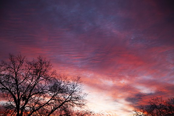
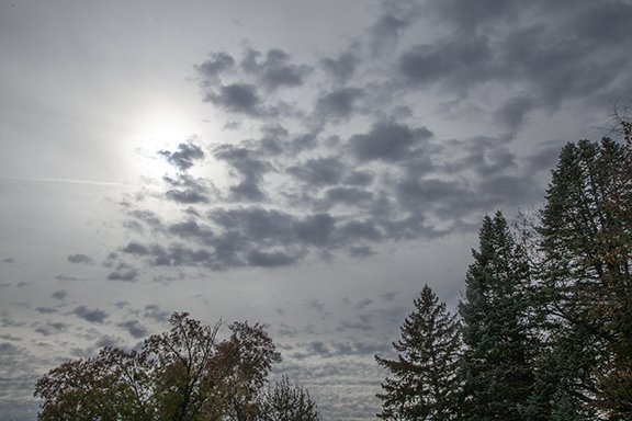
Today began in spectacular fashion with the rising Sun bathing the sky in a red glow. The longer wavelengths of visible red light are making it through the atmosphere on its long trek from just over the horizon to reflect off the Altostratus covering the top half of the photo.
A slightly lighter shade of red is visible behind the trees up to just below a patch of Altocumulus visible just above the second tree from the left at the bottom of the photo.
Whiter Cirrus are visible in the brightest part of the sky as white light is reflecting off ice crystals in the higher colder clouds.

Pink and red dominate the sky below. Notice the subtle ripples of Altocumulus in the middle of a large area of Altostratus that covers most of the photo. The ripples are atmospheric wave clouds. Other areas of ripples are also visible if you look closely.
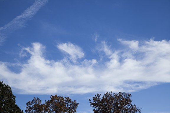
Check out nature’s artistry below. Cirrus formations are some of the most beautiful cloud formations in our skies. The different shapes are caused by changes in the wind direction and wind speed in different atmospheric layers. Upper level layers of air can feature changes in both the direction and speed of the wind. Check out these photos and see if you can guess how these forms appeared. The answers will be coming in the next few days.


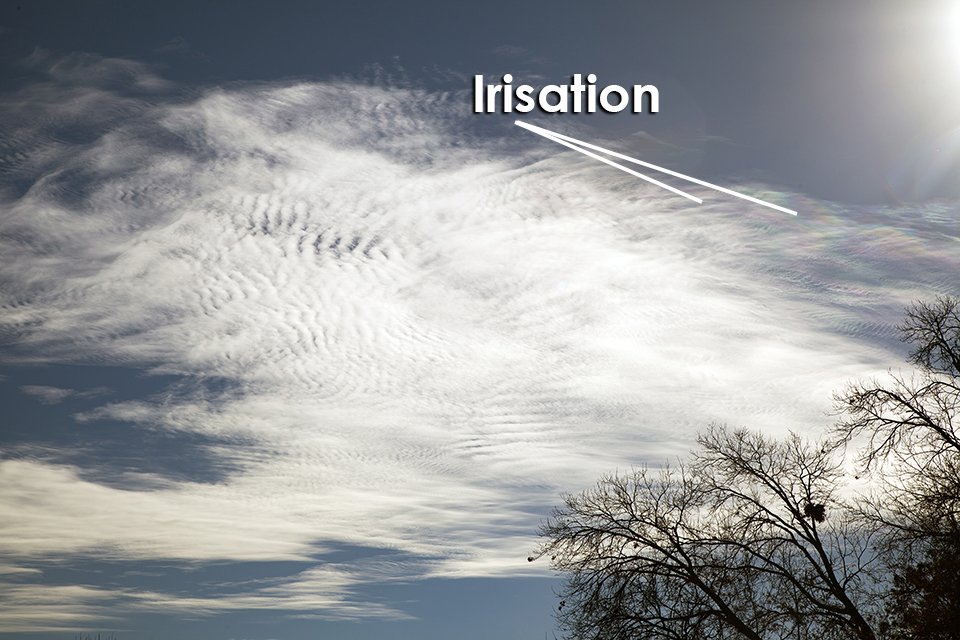
This patch of Altocumulus and Altostratus clouds reveals the optical effect called Iridescence or Irisation. These clouds are excellent producers of irisation which are really small segments of large coronas. Irisation occurs when clouds like these cover the Sun and Moon. In this example the colors range from pink/magenta and light blue to green and yellow. The coloration occurs when light is diffracted by very small cloud particles that are nearly the same size. The particles can be water droplets or ice crystals. Larger ice crystals cause halos instead of irisation if conditions are right.
Depending on your computer monitor the colors may be easy or difficult to see. The sky is not blue because this photo was shot into the Sun which caused the camera to close down the lens aperture to compensate for the bright sunlight. The coloration is extensive along the cloud edge from the where the coloration is indicated to off the edge of the photo. While irisation is relatively rare it does occur often enough for it to be visible several times a year from many locations if you are in the habit of looking for it.
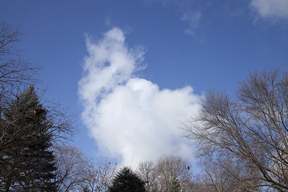
Besides the irisation optical effect described above three cloud types were also represented today in the photos below. The first is Altocumulus cumulogenitus. The cloud formed in the middle levels and turned into this large cumulus shape with ice crystals precipitating from it. The ice gives the cloud its soft edges because ice sublimates rather than evaporates. Sublimation occurs when ice turns from a solid to water vapor without going through the liquid stage. If this cloud were made of water droplets the cloud edges would have been much sharper because evaporation occurs quicker than sublimation.

Altocumulus cumulogenitus
The layer cloud below is Altostratus. There is a hint of a thin line of cloud development from a CONTRAIL left from aircraft engine exhaust. This would be a man-made cloud. The cloud line is too narrow and sharply defined to be natural. The photo above also reveals a CONTRAIL.

Altostratus
The following photo shows precipitating ice crystals fallilng from a small Altocumulus formation. Some of the streamers are falling from an obviously natural cloud formation. The other streamers are falling away from ice crystals falling immediately after forming out of clear air. The streamers are also called virga, which is precipitation not reaching the ground.

Altocumulus with virga.
Cumulus clouds are common in warm weather when warm moist air is heated by the summer sunshine and rises and condenses into puffy clouds like this one. In this case the cloud formed in a much cooler air mass. Clouds form when heating of the air causes rising motion and condensation. There were streamers of ice crystals falling out of the bottom of this cloud but they were not reaching the ground. The clouds in this case were forming because of the differences in air temperature between the ambient air mass and areas of warmer air caused by solar heating. It is similar to what happens when air is heated inside a hot air balloon. In this case the parcel of air is heated and it responds by rising and condensing into the Cumulus cloud that is trailing ice crystal streamers.
The photos below are revealing fall streaks and clouds apparently forming from aircraft engine exhaust. The first photo ice crystals originating out of clear air into falling streamers of ice crystals in very cold air aloft. The crystals are forming at the top of the streamers with the crystals falling away from the origin of formation.
Below those delicate streamers is a denser patch of Cirrus cloud with various filaments of ice crystals being blown by the winds aloft. As you see elsewhere in the cloud photos on other days the differences in wind direction and speed in different layers create awe-inspiring and naturally artistic designs in the clouds.

Below are dramatic Cirrus type clouds trailing dense streamers of ice crystals. Most of the streamers are falling away from dense cloud heads that are cumulus type formations aloft at the cirrus level. In the upper left the streamers are falling immediately out of clear air with no apparent distinguishable head where the streamers begin. The crystals are heavy and large enough to fall immediately upon formation. Where the clouds heads are dense there is enough upward motion to hold the crystals in place until they grow in size enough to fall as streamers. At the bottom of the streamers, where they disappear, the ice crystals are sublimating back into water vapor directly from the ice phase.

I did not witness this cloud formation develop but it looks like it has formed from the water vapor in the engine exhaust of an aircraft condensing directly into ice crystals. These look like Cirrus vertibratus because there are filaments of clouds that are perpendicular to the direction of the parent CONTRAIL that preceded this formation. There are apparently horizontal waves in the clear air that are causing the finger filaments to form horizontally from side to side from the center line of the CONTRAIL. A second example of this process is visible in the left hand photo. It appears to be another CONTRAIL from an aircraft that moved from left to right behind the tree tops.


Talk about a flare for the dramatic! These Cirrus fibratus are being stretched out by strong winds aloft moving from the bottom to the top of the photo.

This photo was shot directly into the Sun which reveals the star-like pattern caused by the sunlight interaction with the camera lens. The layer cloud in the center of the photo is Cirrostratus.

The series of clouds below show some of the beautiful and dramatic cloud formations that form at the cirrus cloud levels above 16,500 feet above sea level. The first photo on the upper left is of a CONTRAIL that has produced cloud streamers (Virga) which are falling ice crystals. The Cirrus fibratus, Cirrus, and Cirrus uncinus in the upper right photo decorate the entire photo frame as ice crystals form and fall in a variety of patterns due to changing wind direction and speeds aloft and falling ice crystals creating streamers.
A CONTRAIL morphed into this unusual formation of ice streamers.
Cirrus uncinus, Cirrus, and Cirrus fibratus are all found in this photo.

Altocumulus cumulogenitus

Cirrofibratus and cirrostratus lower left to upper right. Altocumulus castellanus are across the bottom.

Cirrus uncinus (hook shaped) and Cirrus fibratus
Cirrus debris create a “dashed” cloudline in the upper part of this photo. Other Cirrus and altostratus appear the the bottom of this photo.
Patches of Altostratus or possibly an Altocumulus formation are center-stage in the photo below. The cloud has characteristics of both cloud types. Clouds sometimes do not fit our cloud types which makes it hard to determine what processes are at work.


Cloud streamers dominate this photo as ice crystals fall from dense cloud patches.
I woke up this morning and was welcomed by the sunrise view in the first photo below. The photo shows Altocumulus clouds illuminated by the red glow of the rising Sun. What followed during the day were a series of different varieties of Altocumulus clouds.
These photos reveal several different atmospheric processes. The Altocumulus formed when a layer of relatively warmer (but not warm) air spread over a colder air mass. A layer of unstable air is visible by the lumpy looking clouds. The lumps are plumes of rising air bounded by thin strips of clear skies created by sinking air. We are able to see where the rising air is occurring because of the clouds. The rising air cools it and is causing condensation.
NOTE: clouds may contain both ice crystals and water droplets if the temperature is below freezing. In that case the liquid water is called ‘super-cooled’. Super-cooled water may freeze instantly of it is disturbed.
The degree of instability can be discerned by the depth of the Altocumulus. Thicker Altocumulus occur when the depth of the instability is greater. Thinner Altocumulus occur when the instability depth is shallower.
TO DO: Compare the Altocumulus cloud cells in each photo and between different photos. Individual cloud cells are surrounded by thin ribbons of clear sky or much thinner cloud. The air is rising through each cloud and sinking where the sky is clear. Taller cloud cells are in a layer of deepper instability. The clouds form near the top of the unstable layer layer which has been thoroughly mixed by vertical motions caused by instability. In effect, the layer has been stirred. Broad cloud layers that are smooth are not well-mixed can be home to stratus clouds.

Altocumulus stratiformis (puffy cells with no open sky), Altocumulus undulatus (waves with no open sky), and a ribbon of Altostratus (flat cloud with no open sky) across the bottom of the photo. The stratiformis and undulatus are in continuous cloud layers.
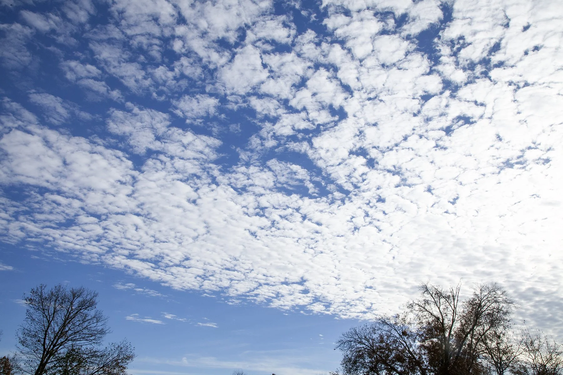
Altocumulus stratiformis
Altocumulus floccus

Altocumulus floccus are in an open cell formation.

Altocumulus floccus on top and Altocumulus undulatus at the bottom of the photo. A CONTRAIL (Condensation Trail) is on the right.
Altocumulus stratiformis form in a broad layer with little vertical extent.

Altocumulus stratiformis with open and closed cloud cells and little vertical extent.

Altocumulus stratiformis have cells in a broad layer with little vertical extent.
When clouds are flat they are called Stratus. Low level flat layered clouds are named Stratus. Middle level flat layered clouds are Altostratus, and higher level Stratus are Cirrostratus. The clouds in the photo below are Altostratus because the cloud base is above 6,500 feet but below 20,000 feet.
How do you estimate the height of cloud bases? Practice makes perfect. Compare the clouds you see with cloud photos. Compare the cloud photos on this website with what you see in your sky. Compare the relative sizes of the cloud formations with what is in your sky as a first guess. In the future I will be including a photo of the sky as shot with a 50 mm lens. That photo will give you the best rendition of the sky as seen with the human eye. Photos that are zoomed in or zoomed out are not how clouds look to us naturally. Hopefully that will give you a better idea of how cloud sizes will look to you without telescopic or wide angle lenses.
You may also purchase our Weather Briefing Cloud ID chart. The description is on our homepage.

Altostratus
Another way is to look at your local National Weather Service website. If you have an airport nearby there may be an hourly observation available. The websites for each NWS region vary somewhat but if you can locate the current weather observation, note the time. It will usually be near the top of each hour. You should see a three-day hourly history of observations. The form may look like the one below.
Count over 6 columns from the left to see the sky condition. On this sample the first row has CLR in it, meaning the sky is clear. Looking down the column the third row shows BKN034. Just put three zeros at the end of 034 and you will get 03400 which would be 3,400 feet. Use that for your local cloud base height. CLR means the sky is clear, SCT means scattered clouds, BKN means broken clouds, and OVC means the sky is overcast.
Happy hunting. The format below use used in the Central Region of the National Weather Service. Your regional may not provide the same detail as below.

Here are two cloud types with the same name that do not look alike. Both cloud types are middle level clouds so their name begins with the prefix ‘alto,’ which means high. In the world of clouds any cloud in the mid-levels gets the prefix ‘alto.’ Examples include Altocumulus or Altostratus.
Altocumulus is a mid-level cumulus cloud and Altostratus is a mid-level stratus cloud. Cumulus and stratus clouds are found in the low levels below 6,500 ft. Because the middle layer is above the low level of clouds they are named high cumulus or high stratus - getting the prefix ‘alto.’ Cumulus and stratus in the highest clouds in the troposphere (where our weather occurs) are named Cirrocumulus and Cirrostratus.

Altocumulus floccus - The clouds look like torn tufts of cotton balls.

Altocumulus stratiformis - a continuous cloud layer of large horizontal extent.
Layered clouds were common in our sky today. On the left are Cirrostratus clouds which are found above 16,500 ft.. On the right are Altostratus which are found between 6,500 and 20,000 ft.

Cirrostratus

Altostratus
We do not see this every day. The unusual cirrus in the first two photos covered most of the sky in random wave patterns. Our atmosphere is filled invisible with wave. When clouds form the waves become visible. Otherwise, we only know they are there if we feel them while flying.
Also in the first two photos are three CONTRAILS from aircraft aloft. The CONTRAILS are condensed water vapor and ice crystals that form in the exhaust plumes from engine exhaust. As the hot ejected from the engines, water vapor condenses in the cold upper air forming clouds with ice crystals and/or tiny liquid cloud droplets.

Cirrus spissatus

Cirrus spissatus
The cirrus below are seen regularly. Cirrus occur in patches or continuous sheets of stratus or cirrus type clouds above 16,500 feet above sea level.

Cirrus and Cirrus fibratus, and Cirrus uncinus with streamers. The photo is looking north.

This photo is also looking North. The only difference is the photos are taken a few minutes apart.

A wider view of the same area of the sky as shown above.
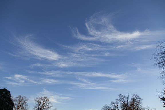
The wind is artistic. Its canvas is the sky and the paint is water and ice. The photos below were taken throughout the day in the order shown below. All but one of the photos below are of Cirrus clouds. With the exception of Cirrocumulus, cirrus are made of ice crystals. Cirrocumulus is the only cirrus type that may have cloud droplets (water) instead of being all ice. Cirrus are formed from the debris left over from a thunderstorm anvil and are found above 16,500 feet to more than 60,000 feet above sea level. They are also formed when rising air aloft condenses what little moisture is in the air into ice clouds. The wind speeds and directions often vary from one layer of air to another, created the fascinating cloud patterns cirrus are well known for. See some examples below.

Cirrus floccus, Cirrostratus, and CONTRAILS

Cirrus uncinus with streamers of ice crystals

Cirrus floccus with Cirrus and Cirrus fibratus

Cirrus floccus and Cirrus fibratus with ice crystal streamers and a CONTRAIL

Cirrus floccus with streamers and a CONTRAIL

Altocumulus floccus

Cirrus floccus, Cirrus spissatus with ice crystal streamers

Cirrus spissatus with a backgrouond of thin Cirrus and a CONTRAIL

Cirrus spissatus with ice crystal streamers

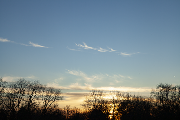
Cirrostratus bathed in Red Sunlight at Sunset
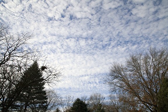
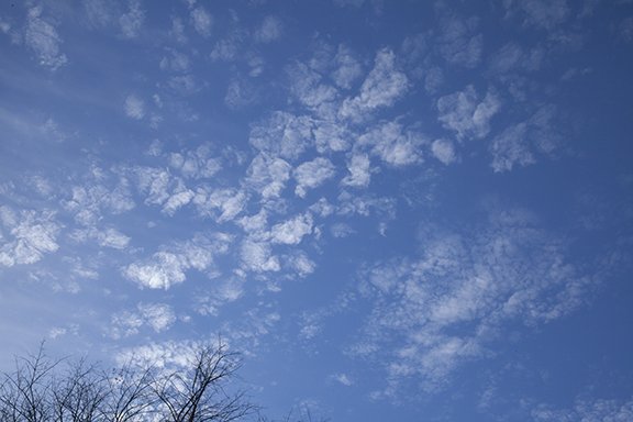
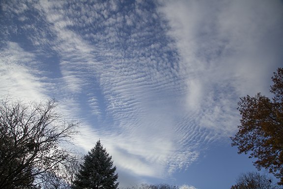
Here is today’s cloud collection. It features low and middle level clouds revealing different atmospheric motions. The lower clouds have a stratus and cumulus component and do so the higher clouds. However, the upper clouds feature the cumulus type while the lower clouds have more of a stratus look. This shows how cloud structures reveal the different air motions that are working at the same time.

Altocumulus floccus and Stratocumulus

Altostratus undulatus and stratocumulus

Altocumulus floccus and Stratocumulus

Sometimes the sky is crystal clear.

Altocumulus floccus with a bird in flight..
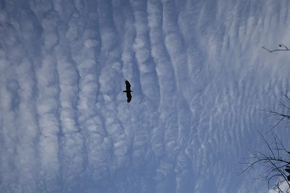
Altostratus undulatus with the bird silouetted against the sky.

Cumulus

Altostratus undulatus, Stratocumulus, Altocumulus lenticularis

Altostratus undulatus and Stratocumulus

Altocumulus Lenticularis and Altocumulus

Altostratus undulatus

Altostratus undulatus
Alto cumulus undulatus, Alstratus undulatus, and Stratocumulus

Altostratus undulatus and Altocumulus above

Stratocumulus undulatus

These Altocumulus could fool you into thinking they are a stratus or a stratocumulus or altocumulus layer. It has the look of all three cloud types. I called them stratocumulus because the nearby airport measured the cloud ceiling at just under 6,500 feet which is the treshold to be named Altocumulus. This illustrates that clouds are not necessarily discrete and easy to identify. The truth is, atmospheric processes are complex so we do the best we can knowing that clouds are on a continuum. Naming them may not be cut and dried.

Naming these clouds suffers from the same problem. Are they a form of cumulus or stratocumulus? You can take your pick.
This photo shows two middle cloud layers present at the same time with each layer caused by different processes. The lower laayer is Altocumulus floccus, meaning the clouds are clumped like flocks of wool. Clear air is located above the Altocumulus. The altocumulus have formed near the top of a mixed layer of air. Vertical motions up and down in the layer have mixed it. The rising motion has created the individual cloud cells which are revealed by the clouds. The air is rising through the clouds and sinking around the he edges of the clouds in what looks like a patch of random cloudiness. Dryer stable air has limited the cloud depth to what is visible in this photo.
A higher Altostratus layer has formed in a sheet of rising motion and moisture. The upward motion is weaker in the Altostratus layer than in the cumulus clouds below. It is probably moving up at a few inches per second most likely induced by stronger winds aloft. Those winds produce alternating regions of upward and downward motions. If moisture is sufficient the coupled areas of up and down motion produce sheets of stratus type clouds that alternate with regions of downward motion where clouds are broken, scattered, or non-existent. That will be a topic for another time.

Cirrus fibratus (center to upper right) are ice crystals being stretched out into long streaks by winds aloft. Thicker Altocumulus are in the upper left and thin Cirrostratus with denser Cirrus spissatus precipitating ice crystals is in the lower center bottom.

This is a chaotic sky at its finest. This photo includes CONTRAILS along with bands of Cirrus fibratus perpendicular to the CONTRAILS. Thin Altostratus in in the upper right. The upper winds are blowing from right to left

The above photo is primarily of Cirrus fibratus. Falling ice crystals are visible as a “haze” covering the fibratus in the left half of the photo. Other fibratus or Cirrostratus is in the lower right behind either Cirrocumulus or thin Altocumulus. In the center foreground are Altocumulus in denser clumps. There appears to be streamers of ice crystals falling away from the patch to the lower center.

Streaks of Cirrus and Cirrus fibratus are streaming parallel to strong upper winds above lower fall streaks falling away from dissipating denser cloud heads. The cloud heads are becoming diffuse as the precipitation weakens.

An altostratus layer overlies Altostratus undulatus clouds below..

Cirrus fibratus which are hairlike cloud fingers, precipitating Cirrus spissatus (dense clusters), and altostratus (far right sheet cloud) indicate three different processes that are forming the clouds in these photos.


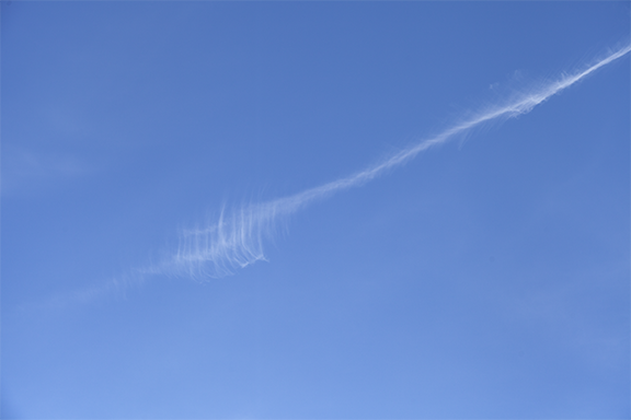
This was a sight. There were five CONTRAILS occupying much of the sky in these unusual formations. The right-hand photo shows three curving CONTRAILS that are lower than a of patch of Cirrus. The CONTRAILS show convective turbulence which precipitated ice crystals.

The photo above includes a CONTRAIL (Condensation Trail) with ice crystal streamers (fall streaks) trailing to the left. The denser CONTRAIL is precipitating the ice crystals.

The cirrus above are Cirrocumulus floccus which are clusters of puffy clouds trailing precipitating ice crystals. The ice crystals are falling away from the denser heads of the cloud clusters where the ice precipitation (ice crystals) are streaming away to the left. The precipitation is forming in the heads where upward motion is strongest. The streamers look like strands of hair which are a classic Cirrus cloud. After the cloud heads stop precipitating all that is left are the streamers which gradually disappear through sublimation (ice crystals turn from a solid to vapor in the cold upper air.
Copyright 2016-2024, Weather Briefing, L.C.
Cedar Falls, IA 50613, Phone: 319-215-2634, Email: craig@weatherbriefing.com