

Fog before the Storm
/
Yesterday (Monday) morning began with fog. Daytime temperatures have been in the upper 30s and 40s during the past couple of days which melted a considerable amount of snow. The weak upper level system that brought clouds and some light precipitation to Iowa Saturday night and Sunday moved east late Sunday clearing the skies. Clear skies, nearly calm winds, and low level moisture from the melting snow was a perfect set up for fog. The fog hung on until winds began to pick up ahead of the large winter storm that has now reached Iowa.
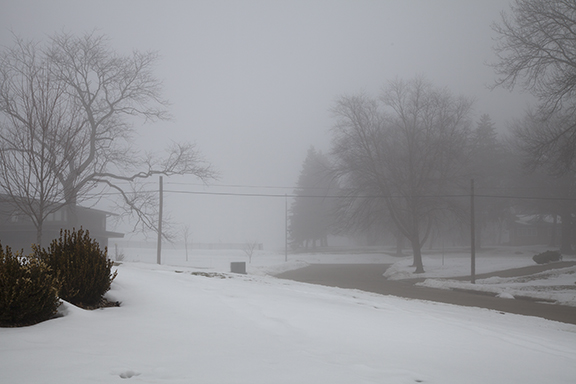
The first photo shows the effect of diminishing visibility as we look north. Note the clearly visible bushes in the foreground and how objects in the distance grow dimmer as light reflected off the trees, homes, and a fence on the hilltop is filtered by the small droplets in the fog.
The photo below enhances the effect. The flag pole in the foreground is distinctly visible but the successive objects fade into the distance as the fog cuts down on the light reaching the camera from the decorative fencing and trees in the distance. The visibility was down to 1/4 of a mile in some locations.
