

Outflow Boundary on Radar
/
If you stand in front of an approaching thunderstorm you feel “it.” “It” is cool air that sweeps out of a thunderstorm. The cool air is a relief on a hot summer day. It is rain cooled, and it comes from thousands of feet above the ground. It splashes, twists, and turns as it reaches the surface.
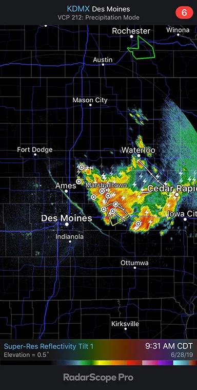
The gust front is the leading edge of the onslaught. Gust fronts are sometimes visible on National Weather Service Doppler radars, as it is in this example. The radar picks up boundaries between warm and cool air. It also is able to detect insects. These radars operate in different modes which allow meteorologists to make the radar more or less sensitive, matching the radar to atmospheric conditions to help them observe what is happening.
The radar image above is from 9:31 am CDT on June 28, 2019. It shows a gust front from northwest to southeast through Ames . The line marks the leading edge of cooler air flowing southwestward out of thunderstorms to the northeast.
Wind speeds along a gust front may be quite strong, sometimes more than 50 mph. In extreme cases speeds winds may exceed 100 mph. Cooler air is heavier than warm air so it flows down and out of a thunderstorm. Depending on the storm and its environment, the outflow spreads in different directions. Most often it moves in advance of a thunderstorm but in this case the outflow was also spreading west and southwest away storms that were moving to the southeast. The radar clearly shows the leading edge of the advance.
Below I have added a very short video from Sunday, June 30, 2019 at 7:02 pm CDT showing cooler air moving toward the southwest. The boundary became visible on radar as it approached the radar location near Johnston, Iowa. Low level winds, like gust fronts, are more likely to be detected when they are close to the radar. Why: The radar beam is higher off the ground at greater distances from the radar making the beam too high to see the leading edge of the cool air. Once the outflow gets close enough to the radar, and conditions are right, it becomes visible on radar. The video was taken with an iPhone XR using the RadarScope Pro App.