

Directional Wind Shear - Seen and Unseen
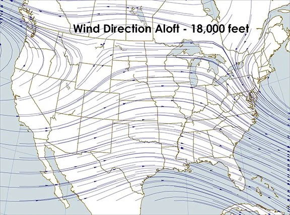
/The two maps below show the wind direction at the surface and at approximately 18,000 feet during the evening of May 5, 2023. The plots are from data provided by radiosonde balloons launched at 0000Z.
Pick the direction of the surface wind where you live and compare it to the wind direction at 18,000 feet. The difference is called the directional wind shear. Notice the difference in the wind direction from the surface to 18,000 feet. For example, at our location in Cedar Falls, Iowa (northeast Iowa), our surface wind was from the southeast. But at 18,000 feet it was from the west.
Why does this matter? One example to mention is knowing the direction shear through the vertical layers of the atmosphere helps forecasters determine the threat of severe weather. It helps to know directional shear, which plays a role in determining what kind of severe weather may occur - such as, whether there would be damaging winds, hail, or tornadoes, or a combination. It also helps in determining where turbulence will occur, which is important information for aviation. I will discuss more on that in another post.
Shear data is available for many layers in the atmosphere. Directional wind sheer is unseen in clear air. When clouds are present directional wind shear may be visible. I am only showing the difference in wind direction between two layers in this example. Many other possibilities exist. Related to this wind direction shear is wind speed shear, also a subject for another post. It is also a type of shear that may be visible when clouds are present. I will use cloud photographs to show you how to locate examples of directional and wind speed shear.

Map plotted by digital Atmosphere software available at www.weathergraphics.com