
Cumulonimbus
/Cumulonimbus, Photo by Craig Johnson
Some clouds are simply majestic! This cumulonimbus was visible from Cedar Falls, Iowa.
The same storm 20 minutes later, Photo by Craig Johnson
To purchase our 24” x 36” full color cloud chart, go to our online store. It is suitable for framing in a standard 24” x 36” frame.

Learn how to identify clouds by following the Clouds of the Day posts below.

Cumulonimbus, Photo by Craig Johnson
Some clouds are simply majestic! This cumulonimbus was visible from Cedar Falls, Iowa.

The same storm 20 minutes later, Photo by Craig Johnson
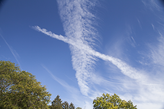
CONTRAILS - (Condensation Trails), photo by Craig Johnson
West to East and South to North contrails over northeastern Iowa on September 30, 2017. The contrails were slowly spreading across the sky. The warm exhaust was creating high cumulus-type clouds overhead. Also in the sky were a variety of cirrus clouds on the right side of the phot.
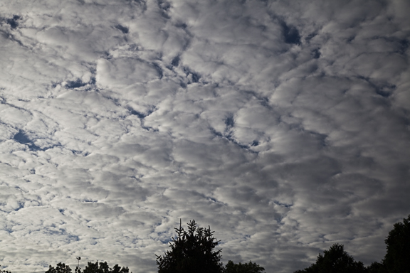
Altocumulus stratiformis, Cedar Falls, Iowa, 10-4-2017 by Craig Johnson
Altocumulus is a middle level cloud (6,000 - 18,000 feet) with cellular vertical development. Stratiformis is a cloud sub-characteristic indicating the cloud also has stratus (flat or layered) structure. This type is typically the thinnest of all altocumulus clouds. Notice the difference in thickness of the cloud layer. Some of the cells, particularly in the lower right quadrant are thicker, showing a more vertical structure. Clouds on the left side of the photo are thinner with a more stratus structure. This cloud type is formed by water vapor that condenses into water droplets.

Photo by Craig Johnson, 7-6-2014
Taking close-ups of clouds can produce spectacular results. This photo of a thunderstorms - close-up - reveals the majestic turbulence found in a thunderstorms. The coloration is due to the filtered light that is common at sunset. In this case, an orange sunset was casting an orange pall over the cloud that was contrasted by low level fractostratus across the top of the image.

Photo by Craig Johnson taken at Cedar Falls Iowa, 11-21-2012

Photo taken at Archest National Park Campground, Utah, by Craig Johnson, 9-24-2012
The setting sun illuminates middle and low clouds with eerie light at Arches National Park, Utah. Clouds take on the color of surrounding light sources that is scattered off water droplets and ice crystals. The most spectacular photos are usually taken within 3 hours of sunrise and sunset because the sun angle creates shadows and adds color to the clouds. Be sure to have your camera handy. This scene lasted only a few minutes. Another hint: Be sure to look behind you too!
We continue to follow the progression of the weather pattern across the United States today.
Note: Learn to read weather maps by learning weather symbol codes and station model plotting schemes here: https://www.weatherbriefing.com/observing-forms
Chilly air associated with surface high pressure covers the eastern U.S., a cold front is moving eastward onto the High Plains, as high pressure builds into the western U.S.
The high pressure center that was centered over Michigan yesterday has moved to NY and PA as of Noon today. The cold front that was crossing the Rockies yesterday has moved eastward to the Dakotas the Nebraska Panhandle and southwest through Colorado to southern Utah.
A few map features to note:
Using the station model plots found on the surface map it is easy to the cloud cover associated with the lift underway in the storm system over the Plains. Colder air behind the front is also producing cloud cover over parts of the Rockies and Great Basin to the west. Minneapolis was reporting light rain at the observation time. A strong southerly flow is underway from Texas to the Canadian Border in the Upper Midwest.

Surface Map, Noon, CDT, Sunday, October 1, 2017; Plotted using Digital Atmosphere, www.weathergraphics.com
The upper air map below shows the air flow over North America today. There is a broad southwesterly flow aloft from the Rockies to the Upper Midwest and western Great Lakes before it turns out of the northwest as it comes around high pressure aloft the ridges from west of Hudson Bay to the Great Lakes south to the Gulf of Mexico. A northwest flow has developed over the Pacific Northwest.

500 Millibar Map, 7:00 a.m., CDT, Sunday, October 1, 2017; Plotted using Digital Atmosphere, www.weathergraphics.com
Let's do a little meteorology.
The upper air map (see the first map below) at 500 mb this morning (approx. 18,000 ft) shows a trough over the East Coast of the U.S. and another over the Northern Rockies. A ridge of high pressure is in between.
Large upper air systems (troughs and ridges) usually have reflections at the surface. The trough in the west is associated with a cold front and low pressure in the Rockies and High Plains. The trough along the East Coast is reflected on the surface by low pressure off Rhode Island and Connecticut with a cold front dropping south just off the coast. The surface high over Michigan this afternoon is a reflection of the upper ridge that extends from NW Canada to Lake Winnipeg then south to Louisiana. Upper troughs are associated with rising motion and upper ridges are associated with sinking motion in the atmosphere.
With sufficient moisture available rising motion creates clouds. Looking at the station model plots on the surface map below we see cloudiness associated with western trough and the eastern trough.

Upper Air Map, 7 a.m. CDT, 9-30-2017 (Plotted using Digital Atmosphere, www.weathergraphics.com)

Surface Map 5:00 p.m. CDT, 9-30-2017 (Plotted using Digital Atmosphere, www.weathergraphics.com)

Surface Map Plot, Noon CDT, 9-25-2017
Plotted by Digital Atmosphere, www.weathergraphics.com
It's that time of year. One day it's summer, the next it is autumn. A stationary front extended from Lake Superior to Iowa and on to the Texas Panhandle at Noon today. Ahead of the front temperatures were in the 80s - definitely summer weather. Behind the front readings dropped into the 70s, 60s, 50s, and 40s.
The map above includes isotherms; dashed lines connecting areas with the same temperature. Notice the tight gradient along and behind the front. The lines are closer together because someone traveling from west to east (east to west) would experience a rapid change in temperature. Traveling parallel to the front someone would experience little or no change in temperature. The coldest temperatures at Noon were found in Wyoming where readings were in the upper 30s into the 40s.
This is a good example on how temperature extremes occur. Ahead of the front winds are from the south and southwest. Behind the front winds are northerly. It makes all the difference in the world which side of the front you are on. The colder air has plunged about as far south as the warmer air has moved north. We can expect more days like today during the next several weeks as we move from summer weather into autumn. Gradually the highs won't be as high and the lows will get colder during October and November when next up comes winter.

Fall streaks descending from cirrus clouds over Cedar Falls, Iowa on September 17, 2017. These streamers are falling ice crystals in sub-freezing air high overhead. The surface temperature was 71 degrees so there was no threat of snow reaching the ground. In fact, the air mass was so dry that the precipitation sublimated - meaning the ice crystals changed directly from ice to vapor in the cold dry air aloft.
Cirrus are precipitating clouds - except the precipitation never reaches the ground. Check out the Weather Briefing Cloud ID Chart. You will see that cirrus are very high. Precipitation would need to fall several miles to reach the ground. It is simply too far to fall before disappearing into thin air as water vapor.

The sky over the Upper Midwest can put on quite a show. These clouds grew into a significant thunderstorm during the next 15 minutes. as they moved eastward. This picture is looking southeast.

This photo was taken on August 21, 2017, a few miles north of the eclipse centerline in western Nebraska. Our location was a few miles north of the Agate Fossil Beds National Monument in the panhandle. The 70 mile wide umbra, which is the darkest part of the Moon's shadow, has shrouded our location leaving only a relatively bright ring of light hugging the horizon in all directions. With the exception of patchy cumulus clouds in the distance the sky was crystal clear. It was a perfect day for viewing the eclipse.
Prior to the arrival of the shadow the western sky appeared to be filled with a "dusty" dark haze. It wasn't dust. It was the shadow approaching from Wyoming. We had pulled off a county road and waited. The shadow raced eastward at 1700 miles per hour. As it passed, the sky darkened - stars appeared and the remaining light provided an eerie illumination over the landscape. The change from 99.99% partial eclipse to totality was incredible. It appeared like a dark shroud wrapping is arms around us in an instant. In ring of light encircled us around the horizon - a 360 sunset (or sunrise) - depending on your point of view. In the photo above the darkness can be seen on the ground and in the sky overhead. The ring of light is plainly visible to the north and it completed a circle around the horizon.
Totality lasted more than two minutes. It was an eerie experience but just as suddenly as it arrived it disappeared leaving an instantaneously bright sky with the "dusty shadow" off to the east. Totality was over. The time was just before Noon, Mountain Daylight Time, but you would never know it by looking at this photo.
A major snowstorm is moving from the eastern Dakotas into parts of Minnesota, Wisconsin, Illinois and Iowa. Click below to view a video shot just before 7:00 pm CDT in Cedar Falls, Iowa. The snow began at 3:50 pm and there is 1.8 inches on the ground at 7:00 pm. 4 to 8" inches is expected with heavier amounts to the northwest through northeast tonight and tomorrow. The last snow fall here was a trace on March 1st. The last measurable snow was on February 24th when 1.2 inches fell. Click on the button to view the video.
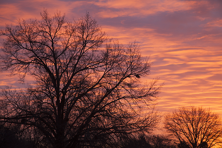
PHoto copyright 2016 by Craig Johnson. Photo taken December 30, 2016.
A layer of wavy mid-level clouds over Cedar Falls, Iowa produced this dramatic sunrise. The red coloration is courtesy of a bright red glow from the rising Sun. The chaotic formation exhibits a variety of wave forms created by gravity waves superimposed on each other.

Mid-morning sunshine sparkled through the tree tops this morning as a coating of ice from yesterday's storm refracted light from the Sun. The Sun was located to the right of this photo. Freezing rain had coated the tree tops with ice setting us up for a unique morning photo..
Sometimes looking at the sky brings surprises. This afternoon we had a very nice example of luminance a relatively rare coloration of the clouds. High clouds were overspreading the sky from the west. The first surge of cloudiness featured cirrocumulus which were painted pink and purple by luminance. The soft glow of color was caused by sunlight being refracted by ice crystals. The ripples in the cirrocumulus look like waves on a lake or the ocean. In fact the waves are caused by the undulation of the air. The waves move through the air like waves on the ocean. Aircraft flying through these waves get a bumpy ride.

Cirrocumulus and cirrostratus with luminance - Photo by Craig Johnson
The luminance of cirrocumulus was soon followed by cirrus fibratus. These fibers took a dramatic pose against the deep blue of the sky. The fibers are streams of ice crystals brushed over the sky by winds aloft.

Cirrus fibratus, cirrostratus, and cirrocumulus photo by Craig Johnson
Within 30 minutes the sky changed again. Instead of the cirrus fibers a gray pall had overspread the sky. Ice crystals were falling filling the layer with a broad layer of precipitation hiding the more fibrous ice crystals above. The sky was smeared with a diffuse layer of ice without a indistinct base, cirrostratus.
It is amazing how fast our sky can change in a matter of minutes. Try looking up several times a day. The show is free for all attendees. The different cloud types reveal a variety of processes and air movement. Try to imagine what might be causing the different cloud shapes that appear and watch here for more explanations in the future.

Cirrostratus photo by Craig Johnson

Contrail
Contrails (condensation trails) form in the exhaust of an aircraft engine. Water vapor is one of the by-products of combustion engines and when the exhaust reaches the cold upper atmosphere the water vapor condenses into water droplets and ice crystals. The contrail above has matured from an initial thin trail to this complex looking pattern. Here the contrail has spread into a broader cloud band that includes cirrocumulus and cirrostratus cloud types. The vertical streamers consist of falling ice crystals that form a narrow cloud band.

Altocumulus are "high cumulus". The name originates from "alto," which means "high" and "cumulus" which means heaped. Altocumulus are found in the middle levels of the atmosphere (between 6,000 to 18,000 feet), higher than cumulus which are found in the low levels (below 6,000 feet). Cumulus in the middle levels are therefore altocumulus (high cumulus).
Cumulus above 18,000 feet are in the cirrus level, a region where temperatures are always below freezing. The clouds consist mainly of ice crystals although water droplets are sometimes found in cirrocumulus, which is the name given to cumulus above 18,000 feet.
In this photo the tops of the altocumulus were illuminated by the setting Sun which helped reveal the vertical structure of the clouds. The photo was taken on the evening of October 5, 2016 at Cedar Falls, Iowa looking northwest. The clouds occurred as moist air in the mid-levels moved into a region of cooler air aloft. The result was an unstable layer that created rising motion in a cellular pattern. The clouds are forming where rising motion cools the air revealing the cloud structure.
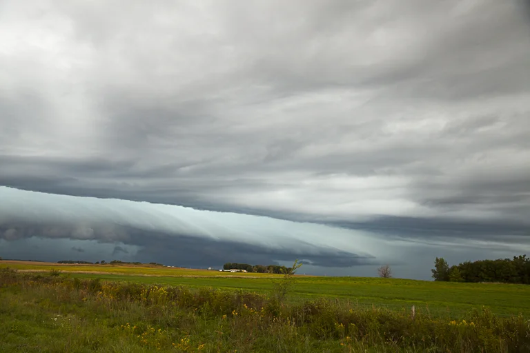
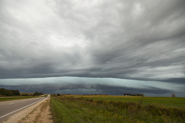
Arcus (Shelf cloud) looking Northwest from HighWay 20 south of Alden, Iowa, Photo by Craig Johnson
Arcus Cloud - Looking west along Highway 20 south of Alden, Iowa, PHOTO by CRAIG JOHNSON
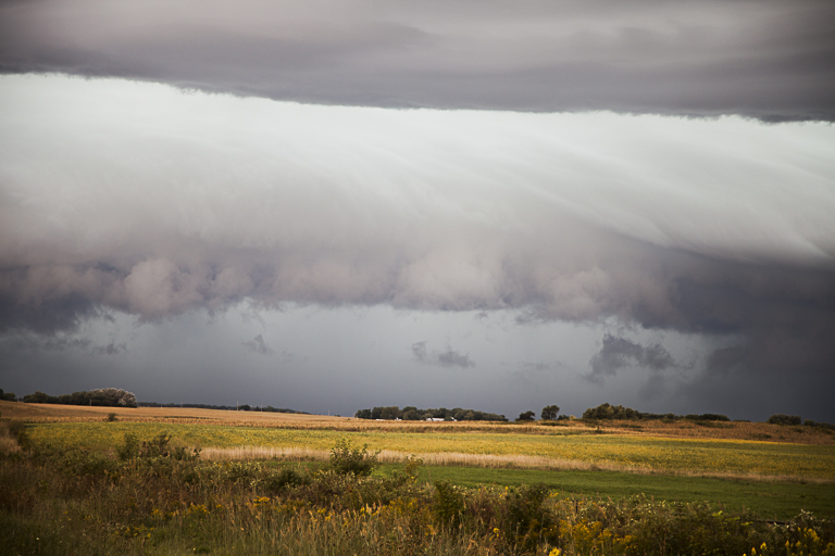
Close-up of Arcus Cloud Looking West along Highway 20 South of Alden, Iowa, PHOTO by CRAIG JOHNSON

Under the Shelf cloud as it moves to the east (Right to Left), PHOTO by CRAIG JOHNSON
This magnificent shelf cloud was photographed facing west along Highway 20 south of Alden, Iowa. The date was Friday, September 9, 2016 at about 3:00 in the afternoon. Shelf clouds are part of the cloud grouping known as arcus. These clouds form along the leading edge of the outflow boundary of the thunderstorm. The outflow is the flow of cooler air descending from a thunderstorms. Outflow from above spreading out over the ground undercuts warm moist air drawn into the parent thunderstorm. Arcus clouds are not attached to the parent cloud. The fourth photo in this series is looking north underneath the shelf cloud. Winds gusted to about 45 mph with the passage of this system.
Copyright 2016-2024, Weather Briefing, L.C.
Cedar Falls, IA 50613, Phone: 319-215-2634, Email: craig@weatherbriefing.com