Clouds of the Day - Monday, June 15, 2020
/Altocumulus and Gravity Waves
The name altocumulus is the primary name of the clouds in these photos. Altocumulus is one of ten principal cloud types. However, clouds may be referred to by a second or sometimes a third name. Altocumulus floccus in the first photo refer to a cumulus type cloud in the middle levels of the atmosphere. In this case the altocumulus resemble tufts of wool so the name becomes altocumulus floccus. Using first and second names better describe how the cloud looks.
The other cloud type in the photo is also altocumulus. This cloud is visible in the lower half of the first photo and in close- ups in the following photos. The cloud includes a broad sheet/layer which is the definition of stratus. Therefore the second name is stratiformis. Finally, there are waves embedded within the broad cloud sheet. The waves give us the name undulatus due to the up and down (undulating) flow associated with waves. The full cloud name is altocumulus stratiformis undulatus.
To be clear, it is fully correct to name the cloud altocumulus without any additional names - altocumulus is the primary cloud name. A fuller description would include the second and third names. To learn cloud names start by learning the ten primary cloud types. If you want, move on to the other names. Otherwise knowing them by just their primary name is correct.

Wide angle View of Altocumulus shortly after 6:00 a.m. CDT. The puffy clouds in the top half of the photo are altocumulus floccus (like tufts of wool)). The altocumulus near the bottom are related to stratus because they are within in a broad sheet or layer. Therefore those clouds are named altocumulus stratiformis. Finally the complete name is altocumulus stratiformis undulatus because the cloud is undulating. See the explanation below.
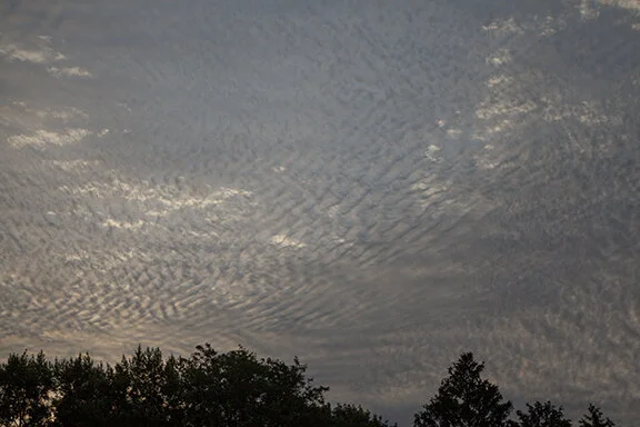
Closer view of the altocumulus stratiformis undulatus. See the explanation below.
The following photos are close-ups of the altocumulus observed this morning. They appear dark, almost like dense fuzzballs because of shadows created by the rising Sun.


Gravity Waves - not Gravitational Waves
Gravity waves in the air form when a stable layer of air is disturbed up or down. For example, a stable layer flowing over a mountain is disturbed similarly to water flowing over rocks. As the water goes over and around rocks waves form and ripple downstream with the flow. The ripples could go with the flow or actually move in a direction somewhat different as determined by the direction the water is flowing and the direction in which the water was disturbed.
If stable air is disturbed upward it will try to move back down to the level it was disturbed. However, it will sink below that level - overshooting it and then move up back toward the initial level and overshoot it before sinking again. This up and down motion will continue until all of the energy in the wave is dissipated. Look at the clouds in the photos above and you will see the up and down motion moving downstream with the flow of air.
The motion in the air makes the gravity waves visible. Where the wave rises cloud forms, where it sinks cloud evaporates. If there is not enough moisture available for condensation the cloud will not form and the waves would not be visible. However, passengers in an airplane flying through the waves would get a choppy or up and down ride.
Gravity waves also form near updrafts and downdrafts of thunderstorms. As these vertical moving shafts of air come in contact with air moving horizontally (wind) they may cause waves, just like air flowing over or around a mountain. The waves would flow downstream or outward from the clashing masses of air. Gravity waves can be seen hundreds of miles downstream from where the waves first formed. The waves are eventually damped out as they lose their up and down energy.
NOTE: Gravity waves are not gravitational waves! Gravitational waves were postulated by Albert Einstein as waves emitted when a massive body accelerates. They were confirmed in 2016. They are not the same as gravity waves.
Cirrus ended the Day
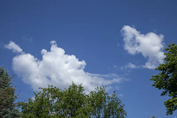
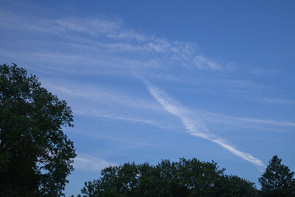
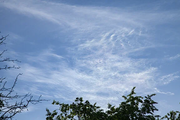
After the morning, the altocumulus and gravity waves gave way to afternoon cirrus. Here are two examples. Both clouds are cirrus - one of the ten principal cloud types. The second characteristic of each cloud is the dense mass of cirrus. Nearly all cirrus are thin - transparent to sunlight or the disk of the Sun. But spissatus are dense clumps of cloud that were originally called cirrus densus; obviously because they are dense or false cirrus because they were so dense they looked like middle clouds. Spissatus are not as common as other cirrus and their source is the top of an old thunderstorm.
The other type of cirrus in each photo is cirrus fibratus. The fibers appear as thin strands of ice crystals that look much like hair. Cirrus fibratus is a common form of cirrus.

Cirrus fibratus and cirrus spissatus

Cirrus fibratus and cirrus spissatus